Volcano Watch: Tsunamis pose a major threat to Hawaii: 24/7 monitoring at PTWC


It’s 3 a.m. and you’re halfway through a 12-6 a.m. graveyard shift at the NOAA Pacific Tsunami Warning Center in Honolulu. Fortunately, you slept before your shift began so you’re feeling alert while you alternate between performing checks on the global seismic and sea level data analysis systems and doing research aimed at improving the speed and accuracy of earthquake magnitude estimation.
The Inouye Regional Center, located on Ford Island in the middle of Pearl Harbor, is quiet and the lights are dim. This time of day at PTWC can be spooky; you and your colleague (asleep in one of the standby rooms) are the only people in the repurposed and modernized World War II-era airplane hangar. Every glimmer and rattle raises your eyebrows.
ADVERTISING
You brew some coffee and as you wait one of your beepers goes off notifying you that an earthquake has just occurred in the southwest Pacific Ocean. You abandon your warm beverage and hustle to the operations center. You have one minute to perform a preliminary assessment before the standby scientist is alerted.
There are only a few seismic stations on remote islands in the southwest Pacific, so it is critical to work fast as the seismic waves propagate outwards from the source. A quick visual inspection of the data scrolling across one of the monitors indicates that a large and potentially tsunamigenic event has just occurred.
The computer-generated automatic solutions confirm your suspicion. The earthquake was shallow and probably had a magnitude (M) greater than 8.5. Your stress level increases but your training has prepared you to handle the event. You immediately send a “PLEASE RESPOND” page to your teammate and you begin to further analyze the seismic information to better constrain the earthquake location and magnitude.
A moment later your coworker emerges ready to assist you with issuing initial tsunami threat messages, forecasting tsunami wave arrival times and amplitudes using numerical models, and monitoring coastal sea-level gauges and seafloor pressure sensors to confirm that a tsunami was generated. The phone rings and you hear the voice of a concerned colleague from the Tonga Meteorological Office on the line. Two minutes have passed since the initial pager alarm sounded. It’s going to be a long and nerve-racking day.
The scenario described above is hypothetical and intended to paint a picture of life working at PTWC. An M8.5 or greater earthquake in the southwest Pacific would likely be deadly; the 2009 M8.1 Samoa Islands earthquake and tsunami killed hundreds of people and caused catastrophic damage to Samoan and Tongan coastal communities and marine ecosystems.
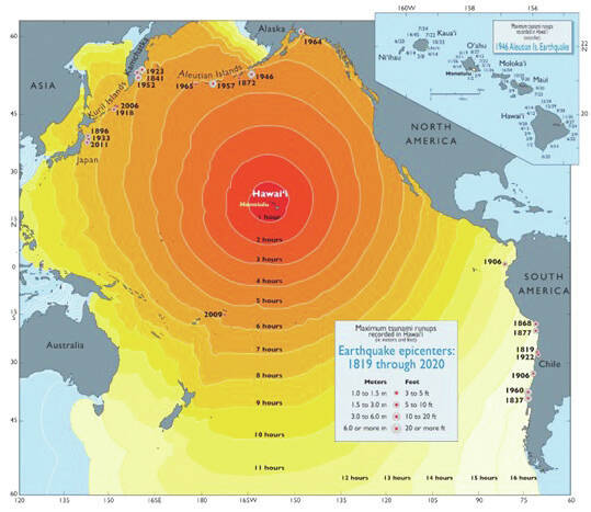
Despite ongoing enhancements to the global network of seismic instruments and continued efforts aimed at improving community preparedness, tsunamis, whether caused by a submarine earthquake, volcanic eruption, or landslide, still pose a major threat globally. The Hawaiian Islands, located in the center of the Pacific Ocean, are in a precarious position. The largest tsunamigenic earthquakes, which typically occur in places like Japan, the Aleutian Islands, and Chile, generate waves that more often than not head directly to Hawaii.
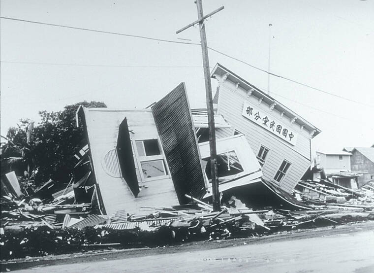
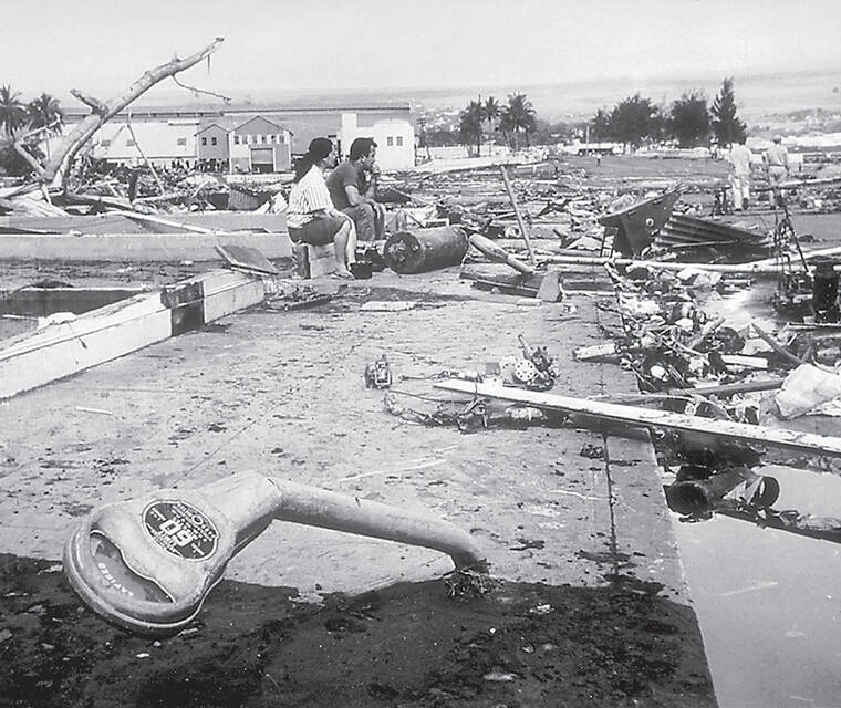
The 1946 M8.6 Aleutian Islands earthquake and tsunami, which led to the establishment of PTWC, killed 159 people in Hawaii. The 1960 M9.5 Chile earthquake (the largest ever recorded) and tsunami caused Pacific-wide destruction and killed 61 Hawaii residents. However, it has been well over half a century since Hawaii was heavily impacted by a damaging tsunami. Even the 2011 M9.1 Japan earthquake and tsunami, which wreaked havoc across large swaths of the Pacific, caused relatively minor damage in Hawaii.
The recent wildfires in Maui have focused a spotlight on natural disaster preparedness and response. In addition, September is National Preparedness Month. Hawaii will likely be threatened again by a potentially deadly tsunami considering the frequency of past events. PTWC, the NOAA National Tsunami Warning Center in Alaska, and Tsunami Service Providers around the world serve as the first line of defense but coastal community residents can do their part to educate themselves about all natural hazards, including earthquakes and tsunamis. For more information visit tsunami.gov and tsunamiwave.org.
Volcano activity updates
Kilauea is not erupting. Its USGS Volcano Alert level is ADVISORY.
The Kilauea summit eruption that began on Sept. 10 stopped on Sept. 16. Summit seismicity has remained low, with very few earthquakes over the past week, and tremor is at background levels. Since the eruption, summit tilt has alternated between minor deflation and inflation. A sulfur dioxide (SO2) emission rate of approximately 240 tonnes per day was measured on September 19.
Mauna Loa is not erupting. Its USGS Volcano Alert Level is at NORMAL.
Webcams show no signs of activity on Mauna Loa. Seismicity remains low. Summit ground deformation rates indicate slow inflation as magma replenishes the reservoir system following the recent eruption. SO2 emission rates are at background levels.
One earthquake was reported felt in the Hawaiian Islands during the past week: a M3.3 earthquake 10 km (6 mi) E of Pahala at 31 km (19 mi) depth on Sept 14 at 7:07 p.m. HST.
HVO continues to closely monitor Kilauea and Mauna Loa.
Please visit HVO’s website for past Volcano Watch articles, Kilauea and Mauna Loa updates, volcano photos, maps, recent earthquake information, and more. Email questions to askHVO@usgs.gov. Volcano Watch is a weekly article and activity update written by U.S. Geological Survey Hawaiian Volcano Observatory scientists and affiliates.