Forecasters: Fire weather watch goes into effect Wednesday for leeward areas
The National Hurricane Center will be posting a fire weather watch for leeward areas of all islands, including Hawaii Island, starting Wednesday afternoon and extending through Thursday afternoon.
According to forecasters, dry fuels combined with strong trade winds and lower humidity could produce critical fire weather conditions Wednesday afternoon through Thursday afternoon.
ADVERTISING
“It is important to note that the winds for this event will not be comparable in strength to the Aug. 8 event, where wind gusts of over 60 mph were observed,” NHC forecaster Amanda Reinhart wrote in a dispatch Tuesday.
Winds are forecast to be trades of 15 mph to 30 mph with gusts of 40 mph to 45 mph. The strongest wind gusts will be downwind of terrain.
Humidity is forecast to be 45% to 50% on Wednesday, lowering to 35% to 45% on Thursday.
Under those conditions, any fires that develop will likely spread rapidly. Outdoor burning is not recommended.
A fire weather watch means that critical fire weather conditions are forecast to occur. Monitor official sources of information for later forecasts and possible red flag warnings.
Hawaii County Civil Defense advises Hawaii Island residents to avoid all outdoor activity that involves an open flame or parking of vehicles on dry grass after travel.
For actions you can take to protect life and property from wildfires, visit the Hawaii Wildfire Management Organization at hawaiiwildfire.org.
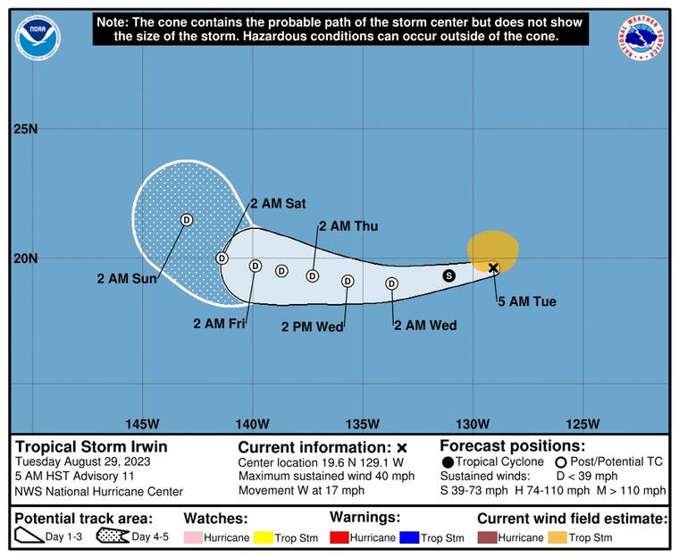
Meanwhile, Tropical Storm Irwin continues to weaken in the Eastern Pacific and according to the NHC is “barely a tropical cyclone.”
Irwin was 1690 miles east of Hilo as of 5 a.m., packing maximum sustained winds of 40 mph and moving west at 17 mph.
This general motion is expected to continue today, followed by a gradually slower westward motion later this week.
Tropical-storm-force winds extend outward up to 105 miles from the center.
Gradual weakening is expected during the next several days, and Irwin could become a post-tropical cyclone later today.
