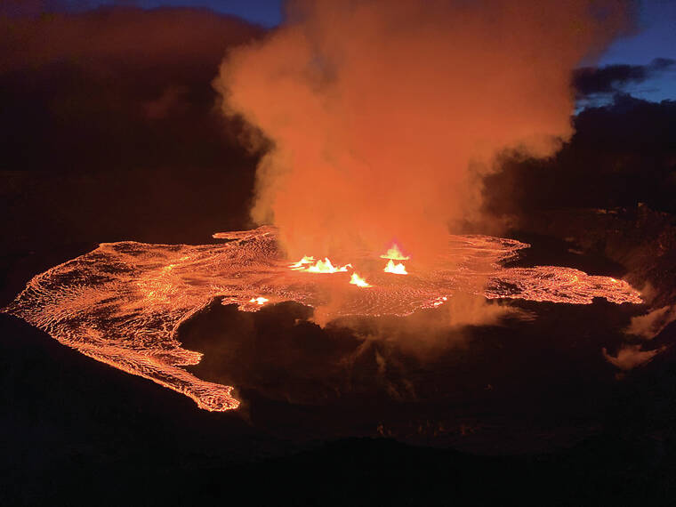
Kilauea volcano began erupting within Halema‘uma‘u crater at the summit during the early morning of June 7. The eruption marks another in a series of recent eruptions that the Hawaiian Volcano Observatory has been able to successfully forecast!
For days to months leading up to all eruptions at Kilauea since 2018, as well as Mauna Loa in 2022, increased earthquake activity and ground inflation suggested that the magma storage systems below were under stress.
HVO scientists have noted these periods of “increased unrest,” and they closely monitor the data streams for signals that an eruption may be imminent. In most recent cases, the signs of an imminent eruption become evident only about an hour before the eruption occurs.
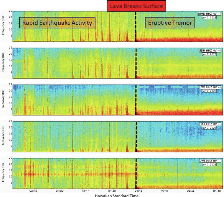
The clearest signals before these recent eruptions are rapidly occurring earthquakes — most not large enough to be felt — as rocks beneath the surface break, along with an increasing rate of inflationary ground motion as pressure builds.
These signals indicate that magma is creating a pathway towards the surface. Eventually, fountains of lava burst from the ground and a conduit is established; volcanic tremor — a signal indicating fluid movement, like the hum of water moving through a garden hose — begins to replace the earthquakes, slowly becoming the dominant signal. Ground motion then begins to deflate, indicating the release of pressure within the magma system.
An outlier is the onset of the January 2023 eruption at the summit of Kilauea. This eruption occurred mere weeks after the previous one had ended in December 2022. Rapid earthquake activity occurred for about 30 minutes, followed by an hour of relative seismic silence before lava broke the surface with eruptive tremor. One hypothesis for why this occurred is the large amount of molten material stored beneath the surface of Halema‘uma‘u crater floor, in combination with the short timeframe following the previous eruption.
With close attention to the data on June 7, HVO scientists were able to identify the precursory activity that closely mirrored previous recent eruptions. Kilauea’s alert level and aviation color code were elevated to WATCH/ORANGE at 3:14 a.m. HST, indicating that an eruption was imminent. HVO field staff were notified and they hurried to the crater rim; just before 4:45 a.m. HST, lava fountains illuminated webcam views and the eruption began. This dynamic activity is confined to Halema‘uma‘u crater within Hawai‘i Volcanoes National Park. If you can’t view it in person, check out the eruption livestream at https://www.youtube.com/usgs/live.
Volcano
activity updates
Kilauea is erupting. Its USGS Volcano Alert level is WATCH.
Eruptive activity is currently confined to Halema‘uma‘u crater within Kilauea’s summit caldera. Multiple minor fountains remain active and active lava covers much of the crater floor. Following the eruption onset, summit tilt has been deflationary and summit seismic activity is dominated by eruptive tremor. Volcanic gas emissions in the eruption area are elevated; a sulfur dioxide (SO2) emission rate of approximately 65,000 tonnes per day was measured on June 7.
Mauna Loa is not erupting. Its USGS Volcano Alert Level is at NORMAL.
Webcams show no signs of activity on Mauna Loa. Seismicity remains low. Summit ground deformation rates show inflation above background levels, but this is not uncommon following eruptions. SO2 emission rates are at background levels.
There were four earthquakes with 3 or more felt reports in the Hawaiian Islands during the past week: a M3.3 earthquake 5 km (3 mi) WSW of Volcano at 0 km (0 mi) depth on June 7 at 4:43 a.m. HST, a M3.4 earthquake 4 km (2 mi) SW of Volcano at 1 km (0 mi) depth on June 7 at 2:35 a.m. HST, a M2.6 earthquake 2 km (1 mi) SSE of Volcano at 1 km (0 mi) depth on June 3 at 12:36 p.m. HST, and a M3.0 earthquake 13 km (8 mi) S of Volcano at 6 km (4 mi) depth on June 2 at 10:15 a.m. HST.
HVO continues to closely monitor Kilauea and Mauna Loa.
Please visit HVO’s website for past Volcano Watch articles, Kilauea and Mauna Loa updates, volcano photos, maps and more. Email questions to askHVO@usgs.gov. Volcano Watch is a weekly article and activity update written by U.S. Geological Survey Hawaiian Volcano Observatory scientists and affiliates.