‘Historic’ swell: Waves swamp Hulihe‘e Palace wedding, overtop townhomes
HONOLULU — Towering waves on Hawaii’s south shores crashed into homes and businesses, spilled across highways and upended weddings over the weekend.
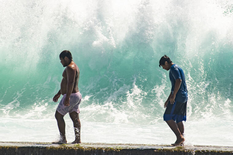
The large waves — some more than 20 feet high — came from a combination of a strong south swell that peaked Saturday evening, particularly high tides and rising sea levels associated with climate change, the National Weather Service said Monday.
ADVERTISING
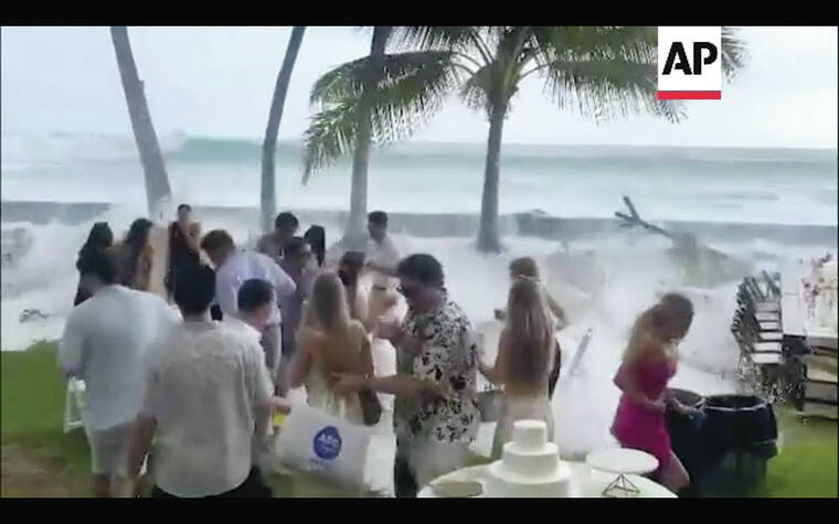
A wedding Saturday evening at Hulihe‘e Palace was interrupted when a set of large waves swamped the event, sending tables and chairs crashing toward guests on the seaside lawn.
Sara Ackerman, an author who grew up in Hawaii and attended the wedding, filmed the waves as they barreled ashore.
“It just was huge,” she said. “I was filming it and then it just came over the wall and just completely annihilated all the tables and chairs.”
She said it happened about five minutes before the ceremony was scheduled to begin.
“It wasn’t like a life-threatening situation by any means whatsoever,” she said. “It was just like, ‘Oh my gosh … what are we going to do? Where are we going to put the tables?’”
She said they went ahead with the ceremony and cleaned up the mess after the newlyweds exchanged vows.
“We had the ceremony and it was beautiful, having all the (sea) spray,” she said. “The ocean was really wild. So it was great for the photos.”
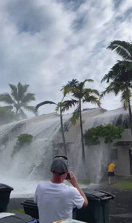
Around the same time, waves hit several ocean-fronting units at the Keauhou Kona Surf and Racquet Club. Video shared widely on social media showed the waves splashing over the tops of the two-story townhomes within the gates of the resort community off Alii Drive. According to police and fire, no injuries were reported.
The extent of the damage remained unclear Monday, Hawaii County Civil Defense Administrator Talmadge Magno said, adding assessment crews had been notified.
However, no one was relocated at the Keauhou Kona Surf and Racquet Club due to damage from the waves, he said. Civil Defense received no other reports of property damage.
“There was a swell was coming through Hawaii, which coincided with high tide around 5:30 p.m,” said Magno. “And while it’s not normal to have this size of a swell, this is a summer occurrence for us, to have storms from Southern Hemisphere push swells into our direction.”
Chris Brenchley, the meteorologist in charge at the National Weather Service office in Honolulu, said several factors came together to create such huge waves.
“Waves over 12 or 15 feet, those become extremely big and really rare to have,” he said. “It’s the largest it’s been in several decades.”
Brenchley said the swell was produced in the South Pacific, where it’s currently the winter season.
“They had a particularly strong winter storm where the winds were focused directly towards places like Samoa and then further on to the north into Hawaii,” he said.
Remnants of Hurricane Darby passed south of Hawaii but had no major impact on the surf, he said.
While singular events like this hard to pin directly to climate change, Brenchley said the warming planet is playing a role.
“The most direct type of impact that we can use with climate change is the sea level rise. Any time you add just even small amounts of water, you raise that sea level just a little bit,” he said. “And now those impacts will be exacerbated whenever we have a large storm event or a … high, high tide.”
Most large summer swells that come from the south are no bigger than about 10 feet, which would trigger a high surf advisory.
“We had some waves that were reaching 20 feet, 20 feet-plus even,” Brenchley said. “That’s getting on the level of historic.”
A high surf warning was slated to end this morning for south-facing shores of Hawaii Island’s east and southeast coasts. Wave heights of 12 to 16 feet were forecast through 6 a.m. Tuesday.
The south swell should decrease slowly Tuesday and drop below the high surf advisory threshold of 10 feet for the south-facing shores on Wednesday. No additional south swells are expected for the Thursday through Saturday time frame, according to the National Weather Service. A small south swell is possible by Sunday.
According to Hawaii County Civil Defense, Old Kona Airport Park and Kohanaiki Beach Park remained closed Monday, all other beach parks closed over the weekend in anticipation of the swell were reopened.
Attempts to reach caretakers of historic Hulihe‘e Palace regarding any damage to the grounds, including Ki‘ope pond, were unsuccessful as of press-time.
West Hawaii Today reporter Megan Hadley contributed to this report.
