Most residents of Hawaii Island live on one of four potentially active volcanoes and probably have wondered about the threat of lava flows at one time or another. Interestingly, determining future threats relies on knowledge of the past. The long-term likelihood of an area being invaded by lava in the future, is estimated in two different ways based on the history of lava flow activity.
One approach uses a geologic map to calculate how much land surface was covered by lava during different periods going back into the past; the resulting numbers are called coverage rates. Another approach calculates how frequently lava flows have occurred within specific areas over time; the resulting number is a lava flow probability.
The 1992 Lava-Flow Hazard Zone Map represents use of the approach based on long-term coverage rates. This is not a measure of how fast an individual lava flow advances but how fast an area is covered by lava from multiple eruptions over centuries. For example, more than one-quarter of Kilauea volcano was covered since Hawaiians hosted the English Captain Cook visiting the islands and almost 90 percent of the volcano was covered since the arrival of Polynesians about 800–1,000 years ago. An evaluation of future activity using these coverage rates would estimate that most of the volcano will be resurfaced by new lava within the next 1,000 years.
New eruptions don’t affect coverage rates significantly, because new flows cover some of the most recent lava as well as older flows. For example, 2018 lava flowed between and over parts of the 1790, 1955, and 1960 lava flows. Therefore the “coverage” or resurfacing since 1790 didn’t increase by the full area of the 2018 flow, just by the portion that was beyond those earlier flows.
The 1992 LFHZ map shows that the highest coverage rates (and therefore hazards) are within the rift zones and summits of Kilauea and Mauna Loa volcanoes. Almost half of LFHZ 1 (the most hazardous zone) on both volcanoes was covered since the year 1790. Coverage rates decrease away from LFHZ 1.
The other approach to estimating long-term lava flow hazards is to calculate how often a particular area is impacted by lava, also called the recurrence interval method.
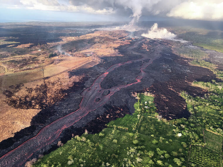
The lower East Rift Zone (LERZ) of Kilauea has been overrun by lava five times since 1790 — in 1790, 1840, 1955, 1960, and 2018. Those eruptions occur over a span of more than 200 years with an average of about 60 years between them.
The recurrence interval method is most widely used for calculating flood hazards, traditionally basing hazard maps on an average recurrence interval of 100 years between damaging floods. By using the simplest formula for probability (ala French mathematician Denis Poisson), that recurrence interval translates to a 1 percent chance of damaging floods happening in any one year and a 39 percent chance in any 50-year period.
The probability of such a flood happening in any century is, surprisingly, not 100 percent but 63 percent (about 3-to-2 odds) because the recurrence interval is an average of actual intervals that may be quite different.
In our application to lava flows, an average recurrence interval of about 60 years in the LERZ means that there is a 63 percent chance (3-to-2 odds again) that the next lava-free recurrence interval will be 60 years; it’s also the odds that another lava flow will affect some part of the LERZ within 60 years.
The probability of a lava flow in this region during the period of 30 years would be 40 percent or odds of 2-to-3 and the probability of flooding would be a 26 percent chance (1-to-3 odds). Fortunately, the region of combined significant lava and flood hazards in the LERZ is limited to coastal flooding zones.
Lava flow hazard calculations and maps produced by the U.S. Geological Survey (USGS) are intended to inform property owners, emergency managers, and government planners of the long-term hazards posed by lava flows.
The USGS Hawaiian Volcano Observatory continues to study lava flow hazards using these and other methods. For more information on Lava Flow Hazard probabilities, the following publications are available: https://pubs.usgs.gov/of/1998/0794/report.pdf and https://pubs.usgs.gov/of/1994/0553/report.pdf.
Volcano
activity updates
Kilauea is not erupting. Its USGS Volcano Alert level is at ADVISORY (https://www.usgs.gov/natural-hazards/volcano-hazards/about-alert-levels). Kilauea updates are issued weekly.
Kilauea volcano is not erupting. Following the recent intrusion of magma beneath the surface in the area south of Kilauea caldera, which slowed substantially on August 30, earthquake rates and ground deformation in this area have remained near pre-intrusion levels. Other monitoring data streams, including sulfur dioxide emission rates and webcam views, show no significant changes. For more information on current monitoring of Kilauea, see https://www.usgs.gov/volcanoes/Kilauea/monitoring.
Mauna Loa is not erupting and remains at Volcano Alert Level ADVISORY. This alert level does not mean that an eruption is imminent or that progression to an eruption from the current level of unrest is certain. Mauna Loa updates are issued weekly.
This past week, about 66 small-magnitude earthquakes were recorded below the summit and upper elevation flanks of Mauna Loa — the majority of these occurred at shallow depths less than 8 kilometers (5 miles). Global Positioning System measurements show no major deformation over the past week. Gas concentrations and fumarole temperatures at both the summit and at Sulphur Cone on the Southwest Rift Zone remain stable. Webcams show no changes to the landscape. For more information on current monitoring of Mauna Loa, see: https://www.usgs.gov/volcanoes/mauna-loa/monitoring.
There were 3 events with 3 or more felt reports in the Hawaiian Islands during the past week: a M3.2 earthquake 2 km (1 mi) SW of Pahala at 32 km (20 mi) depth on Sept. 15 at 7:36 a.m. HST, a M2.6 earthquake 5 km (3 mi) WSW of Kealakekua at 4 km (2 mi) depth on Sept. 15 at 3:09 a.m. HST, and a M3.8 earthquake 6 km (3 mi) ENE of Pahala at 36 km (22 mi) depth on Sept. 12 at 1:45 a.m. HST.
HVO continues to closely monitor both Kilauea and Mauna Loa for any signs of increased activity.
Please visit HVO’s website for past Volcano Watch articles, Kilauea and Mauna Loa updates, volcano photos, maps, recent earthquake info, and more. Email questions to askHVO@usgs.gov.
Volcano Watch is a weekly article and activity update written by U.S. Geological Survey Hawaiian Volcano Observatory scientists and affiliates.