The U.S. Geological Survey has 5 volcano observatories tasked with monitoring low to high threat volcanoes throughout the United States.
Some regions monitored by the volcano observatories had geologically ‘young’ eruptions that are nonetheless old enough to lack written documentation, eyewitnesses, or first-hand accounts. This creates a dilemma for geologists interested in how a future eruption might occur and how long it could last.
The magmas that erupt from these different regions are formed in different ways, and eruptions can range from days, weeks, months, years to as long as several decades in duration. USGS volcano observatories, which include the Hawaiian Volcano Observatory, Cascades Volcano Observatory, Alaska Volcano Observatory, Yellowstone Volcano Observatory, and California Volcano Observatory, monitor many different types of volcanoes and eruptions — from Mount St. Helens in Washington that commonly erupts lava of relatively low fluidity to the more recent eruptions of Kilauea and Mauna Loa, where more-fluid lavas move relatively easily downslope.
California, for instance, has the classic-looking mountainous stratovolcano of Mount Shasta and the large caldera of Long Valley, but neither has erupted historically though each has evidence of geologically young activity. The most recent eruption in California was from 1914–1917 at Lassen Peak, creating a lava dome and related ash deposit, in what is now Lassen Volcanic National Park. An area east of Mount Shasta and Lassen Peak is relatively flat but contains ‘young-looking’ lava flows.
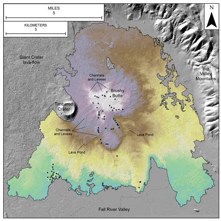
Brushy Butte Volcano is part of this region, and recent field research shows that it contains at least 29 volcanic deposits consisting of scoria and spatter cones and lava flows. One of the outstanding questions surrounding Brushy Butte Volcano is how long did it take to erupt these 29 cones and lava flows?
The problem is that the Brushy Butte eruptions took place approximately 35,000 years ago, and to answer this question CalVO geologists have used the old geologic axiom of ‘uniformitarianism’ or ‘the present is the key to the past.’ This describes the theory that geologic processes occurring now are likely to have occurred in the past, particularly the recent past. To better understand how Brushy Butte erupted and how long it might have taken, active volcanoes of a similar type and setting were used as an analog.
The Brushy Butte Volcano is located in a rifting area, and the type of magma erupted there is called tholeiitic basalt. Kilauea and Mauna Loa, though not exactly the same, are close in that their lavas erupt commonly from rift zones and are usually of a similar tholeiitic basalt type. So, the recent volcanic eruptions from these Hawaiian volcanoes offer a promising glimpse of how lavas erupted from Brushy Butte Volcano may have occurred and how long it might have taken.
One of the most helpful tools used to understand the Brushy Butte eruptions is a method called Light Detection and Ranging or commonly just referred to as LiDAR. The resulting dataset creates a detailed picture of the surface of a lava flow showing the different landforms created as a volcano erupts and lava moves downhill away from its vent.
Much like a river, lava flows can develop channels, levees, breakout channels over the tops of their levees, impoundments that create lava ponds, and lava deltas. These different features formed by lava flows are created over different lengths of time.
Hawaiian volcanoes are very active, and in particular the decades-long eruption of Pu‘u ‘O‘o on Kilauea’s middle East Rift Zone displayed many types of landforms that tholeiitic basalts can form and over what sort of timeframes. Using Pu‘u ‘O‘o as an analog, CalVO geologists estimated that the 29 closely-spaced vents and lava flows of Brushy Butte Volcano erupted over at least 20 years based on the different lava flow landforms created and their placement around the interior of the volcano.
Tholeiitic basalt lava flows in Hawaii and California behave in similar ways. HVO observations from monitoring the 35-year-long Pu‘u ‘O‘o eruption help geologists understand the processes and timeframes that can result in certain volcanic landforms. Kilauea is a natural laboratory for active processes which help provide the key to understanding how volcanic deposits elsewhere formed in the past!
Volcano
activity updates
Kilauea Volcano is not erupting. Its USGS Volcano Alert level remains at NORMAL (https://www.usgs.gov/natural-hazards/volcano-hazards/about-alert-levels). Kilauea updates are issued monthly.
Kilauea monitoring data for the past month show variable but typical rates of seismicity and ground deformation, low rates of sulfur dioxide emissions, and only minor geologic changes since the end of eruptive activity in September 2018. The water lake at the bottom of Halema‘uma‘u continues to slowly expand and deepen. For the most current information on the lake, see https://www.usgs.gov/volcanoes/Kilauea/k-lauea-summit-water-resources.
Mauna Loa is not erupting and remains at Volcano Alert Level ADVISORY. This alert level does not mean that an eruption is imminent or that progression to eruption from current level of unrest is certain. Mauna Loa updates are issued weekly.
This past week, about 26 small-magnitude earthquakes were recorded beneath the upper-elevations of Mauna Loa; most of these occurred at shallow depths of less than 8 kilometers (about 5 miles). Global Positioning System measurements show long-term slowly increasing summit inflation, consistent with magma supply to the volcano’s shallow storage system. Gas concentrations and fumarole temperatures as measured at both Sulphur Cone and the summit remain stable. Webcams show no changes to the landscape. For more information on current monitoring of Mauna Loa Volcano, see: https://www.usgs.gov/volcanoes/mauna-loa/monitoring.
There were 3 events with 3 or more felt reports in the Hawaiian Islands during the past week: a M3.2 earthquake 5 km (3 mi) SSW of Volcano at 1 km (1 mi) depth on Nov. 11 at 4:05 p.m. HST, a M2.9 earthquake 9 km (5 mi) WNW of Kailua-Kona at -2 km (-1 mi) depth on Nov. 10 at 10:33 p.m. HST, a M1.9 earthquake 8 km (4 mi) WNW of Kalaoa at 7 km (4 mi) depth on Nov. 7 at 4:50 p.m. HST.
HVO continues to closely monitor both Kilauea and Mauna Loa for any signs of increased activity.
Please visit HVO’s website for past Volcano Watch articles, Kilauea and Mauna Loa updates, volcano photos, maps, recent earthquake info, and more. Email questions to askHVO@usgs.gov.
Volcano Watch is a weekly article and activity update written by U.S. Geological Survey Hawaiian Volcano Observatory scientists and affiliates.