The Koa‘e fault system connects Kilauea’s East and Southwest rift zones south of the caldera. Faults here appear as low cliffs, or “scarps,” along Hilina Pali Road in Hawaii Volcanoes National Park. These fault-cliffs slip during major earthquakes, such as those of May 4, 2018 — near the beginning of Kilauea’s 2018 eruption.
Koa‘e fault movements have offset ancient lava flows by as much as 15 m (50 ft) throughout a period of centuries. This area provides an important long-term record of motion because of the lack of recent lava flows covering the faults, which makes it an ideal location to study motion of Kilauea’s south flank. More recently, faults have offset roads and footpaths used by early Hawaiians.
So, how much fresh offset took place during and after the 2018 eruption?
A recent “Volcano Watch” article detailed how geodesy, the science of measuring Earth’s shape, is used to measure the shape of Hawaiian volcanoes. New technologies, such as satellite interferometry and GPS, depend on satellites to make geodetic measurements.
One older approach, “leveling,” however, remains a valuable geodetic method some 170 years after it was invented. USGS Hawaiian Volcano Observatory scientists have used it for decades to study our volcanoes, with important results.
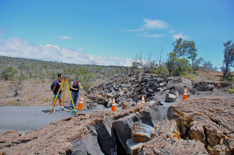
Since the 2018 eruption, the Geology Department at the University of Hawaii at Hilo has partnered with HVO scientists to do “old school” leveling where it is the best approach available. UH-Hilo has capable and enthusiastic geology students, and through the years many have volunteered to measure the cracks and faults.
Leveling uses telescopes aimed at hand-held, graded stadia rods, essentially giant vertical rulers, at specifically positioned field stations. The equipment is used to precisely measure elevation differences between stations marked by stainless steel bolts cemented into bedrock. Horizontal distances between stations are determined with ordinary measuring tapes.
If elevations and distances have changed during the time since the previous measurements, repeat leveling will detect it even down to the millimeter scale!
Leveling requires teams of people working along an established grid in the field, and it’s time-intensive. Field stations are commonly set about 90 m (300 ft) apart.
Fortunately, USGS scientists first began leveling along the Koa‘e faults in the 1960s, providing a long-standing record of data and field stations already in place. Around each leveling station is an array of subsidiary “crack stations,” allowing measurement across individual Koa‘e faults and their related ground cracks.
Going back to the 1960s, we find that in a typical year the roughly 3-km (2-mi) wide land strip encompassed by the Koa‘e fault system widens by about 1.5 cm, just more than half an inch. Individual faults move only a few mm each, about 1/8 of an inch. In contrast, the largest vertical movement recorded during the 2018 earthquakes along a single fault was more than 40 cm (16 in)!
When the Koa‘e faults move, they either slide vertically or open to create a deep crack. A dramatic example of opening was the Hilina Pali Road 2018 faulting near Kulanaokuaiki campground, which split the road. The prominent slope the road ascends is a result of repeated fault movement throughout several hundred years.
Shortly after the end of the 2018 eruption, leveling revealed that the rates of change along the Koa‘e faults quickly returned to the much slower normal pace.
We’ve learned several important things about the behavior of the fault system from the ongoing Koa‘e leveling campaign. Most of the relief along these cliffs is created by large events. The faults are also very efficient “earth movers.” Very few new cracks formed as a result of the large geologic events of 2018.
Instead, motion tends to continue repeatedly along existing cracks, opening them wider and making their scarps taller with time. The motions along the Koa‘e faults are also sensitively tied to what happens elsewhere on the volcano, even many miles away, such as the 2018 earthquakes underneath Kilauea’s south flank and the repeated collapse of the summit caldera.
UH-Hilo students, working closely with scientists, played important roles in collecting and analyzing the data supporting these insights. Thus far, two groups of students have traveled to scientific conferences to present their findings.
We are proud of the contributions these new researchers have made to the Island of Hawaii community and the wider world of science.
Volcano activity updates
Kilauea Volcano is not erupting. Its USGS Volcano Alert level remains at Normal (www.usgs.gov/natural-hazards/volcano-hazards/about-alert-levels). Kilauea updates are issued monthly.
Kilauea monitoring data for the past month show variable but typical rates of seismicity and ground deformation, low rates of sulfur dioxide emissions and only minor geologic changes since the end of eruptive activity in September 2018.
The water lake at the bottom of Halema‘uma‘u continues to slowly expand and deepen.
For the most current information about the lake, see www.usgs.gov/volcanoes/kilauea/k-lauea-summit-water-resources.
Mauna Loa is not erupting and remains at Volcano Alert Level Advisory. This alert level does not mean an eruption is imminent or that progression to eruption from current level of unrest is certain. Mauna Loa updates are issued weekly.
This past week, about 80 small-magnitude earthquakes were recorded beneath the upper-elevations of Mauna Loa; most of these occurred at shallow depths of less than 8 kilometers (about 5 miles). GPS measurements show long-term slowly increasing summit inflation, consistent with magma supply to the volcano’s shallow storage system. Gas concentrations and fumarole temperatures as measured at Sulphur Cone and the summit remain stable. Webcams show no changes to the landscape.
For more information about current monitoring of Mauna Loa Volcano, visit www.usgs.gov/volcanoes/mauna-loa/monitoring.
No felt earthquakes were reported in the Hawaiian Islands during the past week.
HVO continues to closely monitor Kilauea and Mauna Loa for any signs of increased activity.
Visit HVO’s website for past Volcano Watch articles, Kilauea and Mauna Loa updates, volcano photos, maps, recent earthquake info, and more. Email questions to askHVO@usgs.gov.
Volcano Watch is a weekly article and activity update written by U.S. Geological Survey Hawaiian Volcano Observatory scientists and affiliates.