UPDATE: State DOT has plan for possible closure of Daniel K. Inouye Highway


UPDATE 2:20 p.m. Nov. 29
The Hawaii Department of Transportation has plans to close a section of the Daniel K. Inouye Highway if lava from Mauna Loa threatens to cross the road.
ADVERTISING
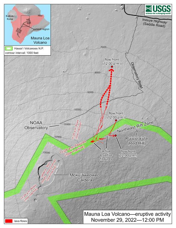
According to a map supplied by the DOT, the department plans to close the highway between the 8.8- and 21-mile markers — the former located just beyond Kaumana in Hilo and the latter a few miles east of the Maunakea Access Road — should lava continue to approach the road. Barricades would be erected at both points, which would be manned by both DOT personnel and law enforcement.
If the highway is closed in this way, signage will be placed around all access points to the highway warning of the closure, and DOT will send notifications to the public through various messaging platforms.
UPDATE 10:05 a.m. Nov. 29
Lava from Mauna Loa is “days away” from potentially reaching the Daniel K. Inouye Highway, known locally as Saddle Road.
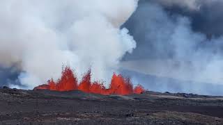
Ken Hon, scientist in charge for the U.S. Geological Survey’s Hawaiian Volcano Observatory, said during a press briefing this morning that the lava flow from Fissure 3 is about 5 to 6 miles long and is oozing slowly toward the highway, about 6 miles away. However, the flow is about 2 miles away from flatter land in the saddle, which Hon said likely will slow the flow and could divert its course.
Hon said that, assuming a constant speed and effusion rate for the flow, it should reach that flatter ground late today or early Wednesday, but added that making such assumptions is premature.
Mayor Mitch Roth said county and state agencies are monitoring the situation. Should the highway be cut off, he said cross-island traffic will have to be diverted to the Hamakua Coast.
Roth also said that the two shelters the county opened Monday in Pahala and Kailua-Kona will be closed today because the lava is not currently threatening any populated area.
A fourth fissure on Mauna Loa’s northeast flank has opened, but Hon said it is currently producing only a minor flow. Fissure 3 remains the main producer of the eruption.
UPDATE 8:40 a.m. Nov. 29
Lava from the ongoing eruption of Mauna Loa has cut off the Mauna Loa Access Road, reports the U.S. Geological Survey.
According to USGS, lava from what is being referred to as Fissure 3 — the lowest of three fissures that opened on Mauna Loa’s northeast flank Monday morning — crossed the Mauna Loa Access Road Tuesday morning. It is the only road to be cut off by the lava so far.
Two additional lava flows from Fissure 3 are moving downrift as well.
Hawaii County Civil Defense reported that the lava is about six miles away from Saddle Road.
UPDATE 5:30 p.m. Nov. 28
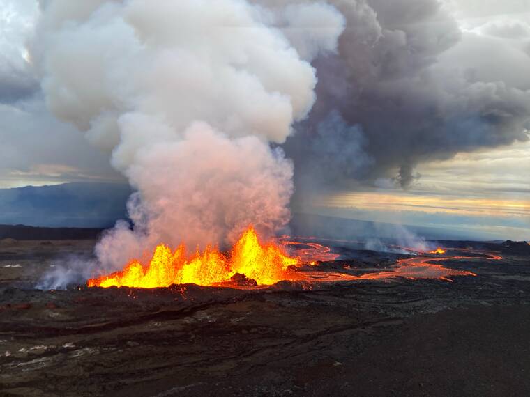
Lava from the eruption of Mauna Loa was about 10 miles from the Daniel K. Inouye Highway earlier today, according to an HVO report just before 5 p.m.
Lava had been erupting from three fissures, but as of 1:30 p.m., only the lowest of the three fissures was active, according to HVO.
Estimates of the tallest fountain heights are between 100 feet and 200 feet, but most are a few yards tall.
The fissures sent lava flows to the northeast and parallel to the rift zone. Lava flows from the two higher fissures moved downslope but stalled about 11 miles from Daniel K. Inouye Highway.
Fissure 3 is currently feeding lava flows moving east parallel to the Northeast Rift Zone. Fissure 3 is currently feeding lava flows moving east parallel to the Northeast Rift Zone. These flows were at 10,000 feet elevation and more than 10 miles away from the highway.
“We do not expect upper fissures to reactivate. However, additional fissures could open along the Northeast Rift Zone below the current location, and lava flows can continue to travel downslope,” HVO said in its report.
There is no active lava within Moku’aweoweo caldera, and there is no lava erupting from the Southwest Rift Zone.
“We do not expect any eruptive activity outside the Northeast Rift Zone,” HVO said. “No property is at risk currently. There is a visible gas plume from the erupting fissure fountains and lava flows, with the plume primarily being blown to the northwest.”
UPDATE 2:19 p.m. Nov. 28
Mayor Mitch Roth said in a statement earlier today that the lava from Mauna Loa “is heading in the best possible direction.”
Hawaiian Volcano Observatory scientists informed county officials that there is no imminent threat — especially to the communities near and around the Southwestern Rift Zone.
Those communities include, but are not limited to, Pahala, Naʻalehu, Ocean View, Miloliʻi, Napoʻopoʻo, Captain Cook, Kealakekua and Keauhou — all of which are considered high-risk in the event of Mauna Loa eruption due to the steep slope of the rift zone.
“Our team is on full alert and is prepared to respond to whatever situation may arise as a result of the Mauna Loa eruption,” Mayor Mitch Roth in a statement.“That said, we’ve been told that the lava is heading in the best possible direction, which is away from our communities. We’ll continue to monitor the situation and will be providing updates to the community regularly. Until then, we thank our state and county partners, departments and agencies for their quick action and attention to every detail.”
It is unclear how long the eruption will last or what the volume output of lava will be.
HVO Scientist-in-Charge Ken Hon said based on history, a typical Mauna Loa eruption lasts about two weeks, “but there’s no guarantee that’s what we’ll get.”
He said HVO is monitoring the flow to determine the speed of the lava, which was erupting from three vents on the Northeast Rift Zone as of noon today.
PREVIOUSLY
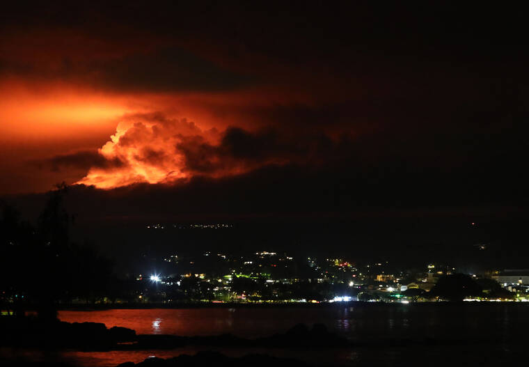
Mauna Loa volcano is erupting.
It’s the first time Mauna Loa, the world’s largest active volcano, has erupted since 1984.
The Hawaiian Volcano Observatory confirmed as of 6:30 a.m. today that lava has exited Mauna Loa summit and can be seen on the northeast flank. Fissures there are feeding several lava flows in the Northeast Rift Zone.
The northeast flank is not populated, and there is no immediate threat to any communities at this time.
The eruption began at 11:30 p.m. Sunday evening in Moku‘aweoweo, the summit caldera of Mauna Loa, inside Hawaii Volcanoes National Park.
Residents at risk from Mauna Loa lava flows should review preparedness and refer to Hawaii County Civil Defense information for further guidance.
As a precaution, shelters are open at Old Kona Airport in Kailua-Kona and Ka‘u Gymnasium in Pahala.
Civil Defense will inform the public of any changes that affect safety.
Since the mid-19th century, Mauna Loa’s Northeast Rift Zone has erupted eight times: in 1843, 1852, 1855-1856, 1880-1881, 1899, 1935-1936, 1942, and 1984. Lava flows from the Northeast Rift Zone can travel in north, west, northwest, south, and southwest directions.
Mauna Loa covers just over half of Hawaii Island.