County, state close beach parks for the weekend as Darby nears
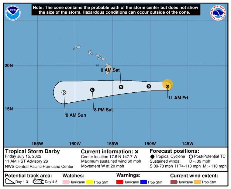
Tropical Storm Darby continues to weaken as it moves toward the south of the Big Island and is expected to bring heavy rain and higher surf to the Big Island this weekend.
At 5 p.m. today, the center of the tropical cyclone was about 400 miles to the east-southeast of Hilo.
ADVERTISING
Maximum sustained winds are 45 mph, and the storm is moving westward at 20 mph. Tropical-storm-force winds extend about 60 miles from the center of the storm.
Darby is expected to weaken to a remnant low on Saturday before dissipating on Sunday. The center of the storm is expected to pass south of the Big Island at some point Saturday.
Large ocean swells are expected to bring higher, possibly hazardous surf in the 15- to 20-foot range in height and dangerous rip-current conditions to island shorebreaks.
Rain is expected to be 2 to 4 inches along portions of the windward Big Island. Flooding could happen along low-lying areas, especially those areas with poor drainage. Breezy tradewinds are expected across the island, with locally higher gusts in the South Point area.
Due to the possibility of dangerous high surf, all county beach and shoreline parks will remain closed on Saturday and Sunday, and the state announced Kua Bay, Hapuna State Recreation Area and Kekaha Kai parks will close on Saturday and possibly on Sunday, as well.