A Hawaii County Council committee today will consider a resolution calling for the purchase of nearly 2,000 acres of rugged coastal land in Kapoho using public land preservation funds.
The Committee on Legislative Approvals and Acquisitions’ Resolution 516-26 authorizes the county finance director to negotiate with seven different lower Puna landowners to acquire a handful of properties — collectively known as “Kumukahi” — with funds from the Public Access, Open Space and Natural Resources Preservation Commission, or PONC.
The land would be opened to the public for recreational, cultural and educational uses, with its native ecosystems and marine resources protected from development.
PONC is an advisory body that identifies lands for the county to obtain using funds derived from 2% of its annual property tax revenues. Parcels nominated by the public are ranked in the commission’s annual reports to the mayor based on opportunities for outdoor recreation, historical and cultural site preservation, natural resource protection including forests, beaches, coastal areas and agricultural lands, and watershed conservation.
The mayor then submits approved nominations to the County Council for authorization. The commission’s 2025 ranking listed Kumukahi as its third-highest priority for preservation.
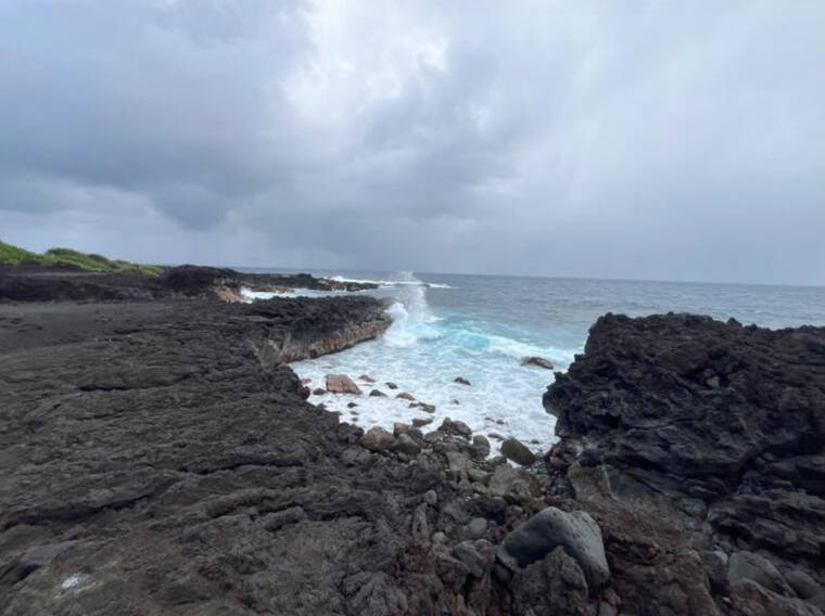
The group of Kapoho properties awaiting the council’s approval make up the easternmost point of Hawaii Island — a craggy landscape of meadow grass, spindly trees and overlapping lava fields from the 1960 and 2018 Kilauea eruptions. It’s the site of Kumukahi Lighthouse, a 125-foot-tall white-painted steel tower which has served as a navigational aid to ships since the 1930s.
It also bears immense cultural significance. Referenced in traditional Hawaiian songs, chants and oral legends as “hikina,” meaning “east,” Kumukahi means “first beginning” or “origin,” referring to the place where the sun first rises at the easternmost point of the island chain. It symbolises beginnings, birth and new life, and a “leina,” or transitional place, where spirits depart from this world into the afterlife.
The land is considered to be a “wahi pana,” meaning a storied or legendary place, as well as a “wahi kupuna,” meaning ancestral place, as it contains burial sites, heiau and other historical features.
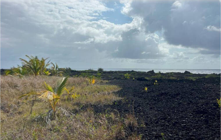
The road leading out to Kumukahi has been impassable for the past eight years, except for a precarious four-wheel-drive path crossing private property that traverses 900 feet of the 2018 lava field. However, this is about to change.
By the end of this year, a 0.15-mile section of Lighthouse Road leading from the intersection of Highways 132 and 137, known locally as “Four Corners,” will be bulldozed open. This imminent renewed access, according to Resolution 516’s text, highlights the need for a management plan for the land, especially considering that the newly forged black sand beach found at the road’s end will inevitably become a major draw for visitors.
“The urgency of acquisition is heightened by the anticipated reopening of the (road) … which will significantly increase public access to Kumukahi, necessitating established stewardship and management infrastructure,” the resolution states.
Ever since road access was cut off in 2018, hikers, mountain bikers and ATV-riders have been accessing Kumukahi using the rocky makeshift path. Before the lava flow, fishermen, hikers and swimmers heading to Kapoho Bay regularly used Lighthouse Road, which caused damage to Kumukahi’s ecology and historical sites.
“Without protective measures in place and established stewards,” the resolution states, “Kumukahi is subject to severe misuse and overuse and this unmanaged access will lead to further degradation of a highly revered and beloved place.”
PONC Chair Deborah Chang agrees that the impending road reopening makes preserving the land a priority.
“The inevitable increase in traffic and visitation makes it a matter of urgency to acquire and manage this sensitive area,” Chang said in an email. “PONC acquisition would enable protective measures to be instituted through a community-based and comprehensive management and stewardship plan. Identification of natural and cultural resources needing protection, strategies for managing access and visitation, protecting native species habitat, educational outreach, building capacity for stewardship of the area, and much more will be necessary components of a management plan. The sooner the planning process can begin, the better.”
It will take careful oversight and vigilance, she said, to stop the cycle of land degradation seen in the past from continuing.
“Proper management and stewardship will be essential to protecting the fragile natural and cultural resources of this area from over-use, vandalism, and abuse,” she said.
Protecting gravesites from further ruin will require input from Hawaiians with ancestral ties to the area, Chang said.
“In addition to utilizing all existing state and county laws,” she said, “it is essential that the lineal and cultural descendants of Kumukahi be encouraged and supported in coming up with the rules and guidelines that should be in place for protection of Kumukahi’s burial grounds and other culturally important sites.”
Email Stefan Verbano at stefan.verbano@hawaiitribune-herald.com.