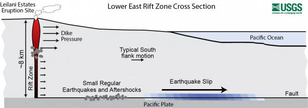
This story begins after Kilauea’s May 4, 2018, M6.9 earthquake and lower East Rift Zone eruption. The M6.9 earthquake resulted in seaward motion at the surface of Kilauea’s south flank of up to approximately 0.5 m (1.5 ft) as measured by Global Positioning System monitoring stations operated by the USGS Hawaiian Volcano Observatory.
Following the 2018 eruption, there was considerable contraction on Kilauea’s middle East Rift Zone that was later followed by expansion or inflation as magma began refilling that area.
The south flank motion resulting from the M6.9 in 2018 was caused by motion deep below the surface, at depths of 7–9 km (4–6 mi), at the interface between Kilauea Volcano and the ocean floor. This interface is known as a décollement or detachment fault. For more information on detachment faults, read this volcano watch article: www.usgs.gov/center-news/volcano-watch-new-research-sheds-light-relationship-between-hilina-fault-system-and.
During the 1983–2018 Pu‘u ‘O‘o-Kupaianaha eruption, and prior to the 2018 M6.9 earthquake, the average rate of motion on Kilauea’s south flank was around 8 cm (3 inches) per year. The flank can move faster or slower, depending on the time period and type of activity on the volcano. Rates can be variable but often remain near-constant during long-duration eruptions, with short-term changes during major rift intrusions and slow-slip earthquakes. For more information on slow-slip earthquakes, read this Volcano Watch: https://on.doi.gov/2N4gER6.
Since the activity in 2018, there has been roughly 10 centimeters (about 4 in) of adjustments along Kilauea’s south flank surface in the last two and a half years. This amount is to be expected and is nothing to be alarmed about.
The motion following the 2018 M6.9 earthquake and eruptive activity was caused by the magmatic intrusion in Kilauea’s East Rift Zone exerting pressure on the south flank. The volcano adjusts after the combined effects of both the intrusion along the East Rift Zone and the large earthquake.
Following the M6.9 and 2018 eruption, Kilauea’s East Rift Zone had been showing inflation consistent with magma supply to the volcano’s shallow magma storage system. However, at the start of Kilauea’s ongoing summit eruption in December 2020, the upper portion of the East Rift Zone started to show signs of contraction. GPS stations along the upper and middle parts of the rift zone started to move northward, which is a rare occurrence on such a short timescale. This was occurring while Kilauea’s summit was deflating at the onset of the eruption.
Kilauea’s south flank’s response to changing magma pressure has been studied extensively through many previous eruptions and intrusions. For example, the 2007 middle East Rift Zone “Father’s Day” intrusion also led to a slight contraction of the rift zone following the intrusion and subsequent eruption. For more information on the Father’s Day intrusion and eruption, read this volcano watch: www.usgs.gov/center-news/volcano-watch-what-do-fathers-day-and-volcanic-rift-zones-have-common.
It’s also common to see elevated rates of motion on faults after large earthquakes. Kilauea’s south flank was the site of 5 earthquakes of magnitude 4.0 or greater in the past year. The M4.1 earthquake this past Monday, February 1, 2021, beneath the south flank is one of the five and it was felt across the Island of Hawaii. These earthquakes happen in response to abrupt motion of the detachment fault which moves to the southeast over the oceanic crust. The abrupt motion releases pressure on the south flank that is caused by magma accumulation beneath the surface.
The relationship between tectonics and volcanism of the Hawaiian Islands is widely studied and the story of Kilauea’s south flank continues to unfold in time. HVO’s dense monitoring network of GPS stations allows us to closely monitor and report these changes, while also giving us the opportunity to learn more about the volcano’s behavior.
Volcano
activity updates
Kilauea Volcano is erupting. Its USGS Volcano Alert level is at WATCH (https://www.usgs.gov/natural-hazards/volcano-hazards/about-alert-levels). Kilauea updates are issued daily.
Lava activity is confined to Halema‘uma‘u with lava erupting from a vent on the northwest side of the crater. As of the morning of Feb. 4, the lava in the western, active portion of the lake in Halema‘uma‘u was about 212 m (696 ft) deep, with the eastern portion of the lava lake solidified at the surface. Sulfur dioxide emission rate measurements made on Feb. 1 were about 2,200 t/d, below the range of emission rates from the pre-2018 lava lake.
Summit tiltmeters show the continuation of deflationary tilt over the past day. Seismicity remains elevated but stable, with elevated tremor and a few minor earthquakes. For the most current information on the eruption, see https://www.usgs.gov/volcanoes/Kilauea/current-eruption.
Mauna Loa is not erupting and remains at Volcano Alert Level ADVISORY. This alert level does not mean that an eruption is imminent or that progression to eruption from current level of unrest is certain.
Mauna Loa updates are issued weekly.
This past week, about 95 small-magnitude earthquakes were recorded beneath the upper-elevations of Mauna Loa; most of these occurred at depths of less than 8 kilometers (about 5 miles). Three magnitude 3 earthquakes occurred on the lower flanks of the volcano over the past week. Global Positioning System measurements show continued slow summit inflation, consistent with magma supply to the volcano’s shallow storage system. Gas concentration at the Sulphur Cone monitoring site remain stable (below 2 ppm SO2). Fumarole temperature was approximately 80 degrees Celsius (176 degrees Fahrenheit). This value is in the normal range. Webcams show no changes to the landscape. For more information on current monitoring of Mauna Loa Volcano, see: https://www.usgs.gov/volcanoes/mauna-loa/monitoring.
There were 7 events with 3 or more felt reports in the Hawaiian Islands during the past week: a M3.1 earthquake 6 km (3 mi) E of Pahala at 35 km (22 mi) depth on Feb. 3 at 11:04 a.m. HST, a M4.1 earthquake 13 km (8 mi) SSE of Fern Forest at 6 km (3 mi) depth on Feb. 1 at 2:09 p.m. HST, a M2.7 earthquake 2 km (1 mi) W of Pahala at 35 km (21 mi) depth on Jan. 31 at 12:23 p.m. HST, a M3.2 earthquake 21 km (13 mi) N of Pahala at 8 km (5 mi) depth occurred on Jan. 29 at 9:10 a.m. HST, a M3.2 earthquake 21 km (13 mi) SSE of Honaunau-Napoopoo at 9 km (5 mi) depth on Jan. 29 at 6:33 a.m. HST, a M3.1 earthquake 21 km (13 mi) SSE of Honaunau-Napoopoo at 8 km (5 mi) depth on Jan. 29 at 6:30 a.m. HST, and a M2.0 earthquake 19 km (11 mi) SSE of Waimea at 24 km (15 mi) depth on Jan. 29 at 1:30 a.m. HST.
HVO continues to closely monitor both Kilauea’s ongoing eruption and Mauna Loa for any signs of increased activity.
Please visit HVO’s website for past Volcano Watch articles, Kilauea and Mauna Loa updates, volcano photos, maps, recent earthquake info, and more. Email questions to askHVO@usgs.gov.
Volcano Watch is a weekly article and activity update written by U.S. Geological Survey Hawaiian Volcano Observatory scientists and affiliates.