On the evening of Thursday, Oct. 22, people living near the summit of Kilauea Volcano began to feel a series of earthquakes. They were small, and some could even be mistaken for a strong gust of wind blowing against the house.
As the night went on, they became more frequent and larger in magnitude. Beds were shaken enough to wake people up, and household items were rattling. People were wondering, “Why are there so many earthquakes? How big will they get? Is an eruption coming?”
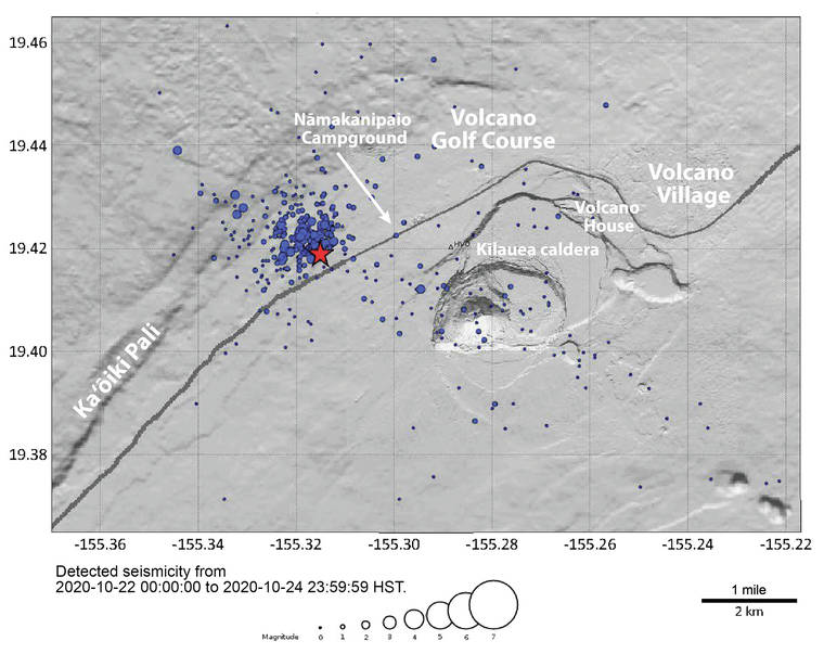
As it turns out, a shallow seismic swarm had begun west of Kilauea Volcano’s summit, near Namakanipaio Campground. The largest single event was a magnitude-3.5 earthquake on the morning of Sunday, Oct. 25, at 5:08 a.m. local time. And an imminent eruption does not appear to be likely.
USGS Hawaiian Volcano Observatory scientists were closely monitoring these earthquakes from the onset, and issued a Kilauea Information Statement on Oct. 23. The summary stated that “Kilauea Volcano is not erupting. A small swarm of shallow seismicity over the past 24 hours has occurred near the Ka‘oiki fault system, northwest of Kilauea’s summit. Other Kilauea monitoring data streams remain stable and show no signs of increased activity.”
HVO monitors Hawaii’s active volcanoes in a variety of different ways. Our seismic network monitors earthquakes. Our geodetic network monitors ground “deformation”— changes in the shape of the Earth’s surface. Our gas network measures volcanic gas emissions. Our camera network monitors visual and thermal features, to name a few.
Throughout this recent seismic swarm, no significant changes were observed in any of HVO’s other monitoring data streams. This differs from the events leading up to Kilauea’s 2018 eruption for example, when in addition to earthquakes, geodetic sensors measured dramatic changes in deformation due to the accumulation and migration of magma.
This seismic swarm continued in earnest through the weekend. Residents of the Volcano Golf Course neighborhood in particular had a few restless nights and reported weak shaking associated with some of the earthquakes on the USGS “Did You Feel It?” website. But activity gradually diminished, and the number of earthquakes is now back to near “background” levels.
Although Kilauea and Mauna Loa are not currently erupting, they are both active volcanoes and there is constant “background” activity going on within these volcanoes. This background activity can lead to, and include, things like this recent earthquake swarm. The Ka‘oiki fault system is located along the structural interface between these two active volcanoes.
HVO has detected several similar Ka‘oiki seismic swarms since 1983. For more information on earthquakes in this area, please see the Volcano Watch article titled, “Why do swarms of earthquakes occur around the Ka‘oiki Pali?” published by HVO scientists in 2012: https://www.usgs.gov/center-news/volcano-watch-why-do-swarms-earthquakes.
Earthquakes are part of life on an active volcano. A Volcano Watch article earlier this month described “The Great Hawaii ShakeOut” exercise that took place on October 15th. This Ka‘oiki seismic swarm is yet another reminder for Hawaii residents to be prepared for earthquakes.
Coincidentally, Island of Hawaii residents also reported strong smells of sulfur or vog (volcanic air pollution) over the past week. HVO’s gas monitoring instruments have not recorded any increases in volcanic emissions of SO2 or H2S however. Why, then, have these smells been more noticeable?
The most likely reason is Kona winds. For the past week or so, Hawaii has been experiencing winds coming from the south instead of typical trade winds from the northeast. Not only is the wind direction different, but some places that usually have a constant breeze are experiencing still air. As a result, even though volcanic gases emanating from Kilauea have remained at consistent “background” levels, they are being blown around and concentrated in different places than normal.
Between seismic swarms leading to sleepless nights, and sulfur smells leading to wrinkled noses, it has been a somewhat interesting week for Island of Hawaii residents!
One thing remains the same — just like every week, HVO scientists are vigilantly monitoring volcanic activity. There is currently no eruption, or signs that an eruption is imminent. But the events of the past week serve to illustrate why HVO scientists constantly monitor and study the volcanoes we live on. Things can, and do, change at any time.
Volcano
activity updates
Kilauea Volcano is not erupting. Its USGS Volcano Alert level remains at NORMAL (https://www.usgs.gov/natural-hazards/volcano-hazards/about-alert-levels). Kilauea updates are issued monthly.
Kilauea monitoring data for the past month show variable but typical rates of seismicity and ground deformation, low rates of sulfur dioxide emissions, and only minor geologic changes since the end of eruptive activity in September 2018. The water lake at the bottom of Halema‘uma‘u continues to slowly expand and deepen. For the most current information on the lake, see https://www.usgs.gov/volcanoes/Kilauea/k-lauea-summit-water-resources.
Mauna Loa is not erupting and remains at Volcano Alert Level ADVISORY. This alert level does not mean that an eruption is imminent or that progression to eruption from current level of unrest is certain. Mauna Loa updates are issued weekly.
This past week, about 36 small-magnitude earthquakes were recorded beneath the upper-elevations of Mauna Loa; most of these occurred at shallow depths of less than 8 kilometers (about 5 miles). Global Positioning System measurements show long-term slowly increasing summit inflation, consistent with magma supply to the volcano’s shallow storage system. Gas concentrations and fumarole temperatures as measured at both Sulphur Cone and the summit remain stable. Webcams show no changes to the landscape. For more information on current monitoring of Mauna Loa Volcano, see: https://www.usgs.gov/volcanoes/mauna-loa/monitoring.
There were 7 events with 3 or more felt reports in the Hawaiian Islands during the past week: a M3.3 earthquake 2 km (1 mi) SSW of Volcano at 0 km (0 mi) depth on Oct. 29 at 1:04 a.m. HST, a M3.5 earthquake 9 km (5 mi) ENE of Pahala at 31 km (19 mi) depth on Oct. 25 at 6:02 p.m. HST, a M3.5 earthquake 8 km (4 mi) WSW of Volcano at 4 km (2 mi) depth on Oct. 24 at 5:08 a.m. HST, a M2.8 earthquake 8 km (4 mi) WSW of Volcano at 4 km (2 mi) depth on Oct. 24 at 1:46 a.m. HST, a M3.0 earthquake 9 km (5 mi) WSW of Volcano at 3 km (2 mi) depth on Oct. 23 at 1:43 a.m. HST, a M1.4 earthquake 9 km (5 mi) WSW of Volcano at 3 km (1 mi) depth on Oct. 23 at 1:19 a.m. HST, and a M2.7 earthquake 8 km (4 mi) WSW of Volcano at 3 km (2 mi) depth occurred on Oct. 23 at 12:13 a.m. HST.
HVO continues to closely monitor both Kilauea and Mauna Loa for any signs of increased activity.
Please visit HVO’s website for past Volcano Watch articles, Kilauea and Mauna Loa updates, volcano photos, maps, recent earthquake info, and more. Email questions to askHVO@usgs.gov.
Volcano Watch is a weekly article and activity update written by U.S. Geological Survey Hawaiian Volcano Observatory scientists and affiliates.