Many messages to AskHVO (askHVO@usgs.gov) request resources relating to geologic maps and geographic information systems (GIS) data. “Is there a map of a certain lava flow?” “Where can I find the associated GIS data?” All HVO and USGS publications are searchable at https://pubs.er.usgs.gov/, but this service is most effective if you already know what to look for.
HVO has its own list of publications available online. Another way to find this page is by clicking “Publications” in the “Quick Links” section on the right side of the HVO homepage. This list includes selected publications relating to Hawaiian volcanism. Recently, it has been updated with geologic map and GIS products of interest to citizen-scientists.
These products are compiled at varying scales and cover different regions of the State, so it may be difficult to determine quickly which is best for your specific interest. To help, here we review some of these maps and data sets, from larger (State-wide) to smaller (sectors of a volcano). Use the list of publications on the HVO web site to find links to each product.
The Geologic map of the State of Hawaii was prepared by Dave Sherrod and others (2007; scale 1:100,000); this publication also includes GIS data. Most of their mapping for the Island of Hawaii was borrowed from the important island-wide geologic map by Edward Wolfe and Jean Morris (1996; 1:100,000) and the digital database by Frank Trusdell and others (2005; 1:100,000). However, these maps are coarser than the finer-scale products discussed below. Only lava flows from the modern historical period — CE 1790 through the publication date — were identified individually, with older lavas being grouped into broader age ranges.
For volcanoes on the other islands, such as Haleakala on Maui, the Sherrod and others publication remains the definitive source.
Several geologic maps cover the Island of Hawaii and individual volcanoes. For Maunakea, Wolfe and others (1997; scales vary by region) mapped from the summit to the Kohala coast as part of a report on the geology of the volcano. A map of Hualalai was prepared by Richard Moore and David Clague (1991; 1:50,000), with a finer-scale inset of the summit region (1:24,000).
For Mauna Loa, there are very recent products for the northeast, central-southeast, and southern flanks by Frank Trusdell and John Lockwood (2017, 2019, and 2020, respectively), which include both detailed geologic maps (1:50,000) and GIS data (1:24,000). Two more geologic map publications will cover the remainder of the volcano. Additionally, maps and GIS data for lava inundation zones on Mauna Loa were published by Frank Trusdell and Michael Zoeller (2017; scales vary by region).
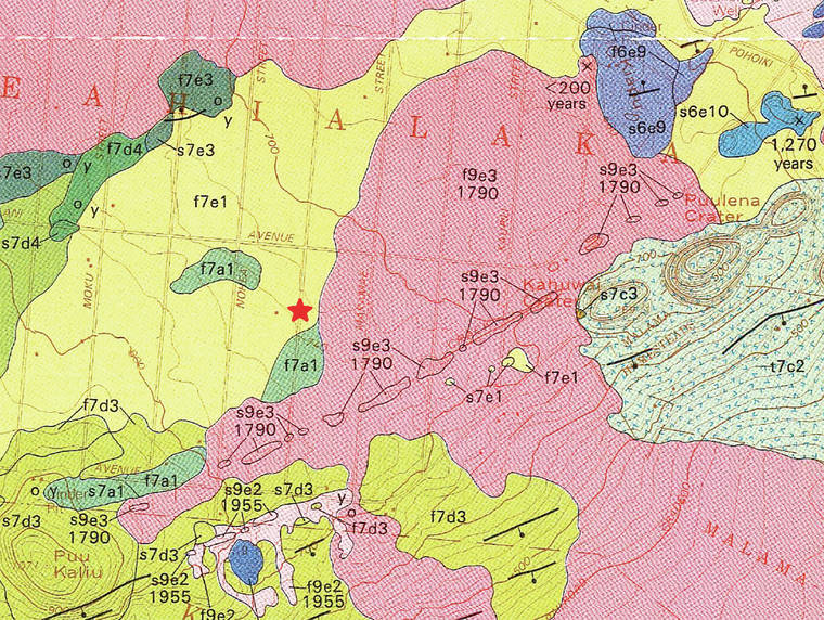
Geologic map products for Kilauea are more fragmented, since there has been no recent map or series of maps dedicated to the entire volcano. 1980s geologic mapping by Robin Holcomb was incorporated into the work of Wolfe and Morris (1996) and subsequent products; maps with finer detail have only been published for certain sectors of Kilauea.
For the summit region, there is a map by Christina Neal and John Lockwood (2003; 1:24,000) and a GIS database by Dillon Dutton and others (2007; 1:24,000). For middle East Rift Zone, Trusdell and Moore (2006; 1:24,000) published the Geologic map of the middle East Rift geothermal subzone; Zoeller and others (2019; 1:24,000) produced the associated digital database. For the lower East Rift Zone — including areas buried by lava in 2018 — there is a map by Moore and Trusdell (1991; 1:24,000).
Importantly, more than 35 years of eruptive activity from 1983 to 2018 mean that most of these Kilauea maps are in serious need of revision!
HVO’s publication list also includes several standalone GIS datasets. James Kauahikaua and others (2016) calculated steepest descent lines for Kilauea, Mauna Loa, Hualalai, and Maunakea which enable us to visualize plausible, topographically influenced lava flow paths. Tim Orr (2018) published GIS shapefiles for historical Kilauea lava flows from CE 1790 through 1982. There are also GIS shapefiles depicting progression of two Pu‘u ‘O‘o lava flows: the episode 61g flow from May 2016 through May 2017, by Orr and others (2017), and the June 27th flow from June 2014 through June 2016, by Orr and Patrick (2019).
As HVO’s bibliography of maps and other geospatial data sets grows, our online publications list will be updated accordingly. We will keep you posted!
Volcano
activity updates
Kilauea Volcano is not erupting and remains at Volcano Alert Level NORMAL (https://volcanoes.usgs.gov/vhp/about_alerts.html). Kilauea updates are issued monthly.
Monitoring data show no significant changes in seismicity, sulfur dioxide emission rates, or deformation.
The water lake at the bottom of Halema‘uma‘u continues to slowly expand and deepen. For the most current information regarding the depth of the lake, see https://volcanoes.usgs.gov/volcanoes/kilauea/summit_water_resources.html
Mauna Loa is not erupting and remains at Volcano Alert Level ADVISORY. This alert level does not mean that an eruption is imminent or that progression to eruption from current level of unrest is certain. Mauna Loa updates are issued weekly.
During the past week, HVO seismometers recorded 62 small earthquakes beneath the volcano’s summit and high-elevation. Most of these occurred less than 8 kilometers (~5 miles).
Global Positioning System measurements show continued slow summit inflation, consistent with ongoing magma supply to the volcano’s shallow storage system.
Gas concentrations at the Sulphur Cone monitoring site on the Southwest Rift Zone remain stable. Fumarole temperatures as measured at both Sulphur Cone and the summit have not changed significantly. This week, a new multi-gas monitoring station was installed in the summit caldera.
For more information on current monitoring of Mauna Loa Volcano, see: https://volcanoes.usgs.gov/volcanoes/mauna_loa/monitoring_summary.html
HVO continues to closely monitor both Kilauea and Mauna Loa.
Felt earthquakes
There was 1 event with 3 or more felt reports in the Hawaiian islands during the past week. A magnitude-2.5 earthquake 8 km (5 mi) SW of Kahaluu-Keauhou occurred on April 23, 2020 at 6:15 p.m. HST.
Volcano Watch (https://volcanoes.usgs.gov/hvo/hvo_volcano_watch.html) is a weekly article and activity update written by U.S. Geological Survey Hawaiian Volcano Observatory scientists and affiliates.
Please visit HVO’s website (https://volcanoes.usgs.gov/hvo) for past Volcano Watch articles, Kilauea and Mauna Loa updates, volcano photos, maps, recent earthquake info, and more. Email questions to askHVO@usgs.gov.