Even though Kilauea Volcano’s lower East Rift Zone eruption has been over for about a year, steam continues to appear in new places or reappear in old places, and vegetation continues to die because of lingering heat and steam in areas of the 2018 fissures.
Some residents are concerned about continuing (or potentially new) volcanic activity in the lower East Rift Zone because they are feeling, seeing and smelling the heat, steam and odors that remain in the area. In fact, the most common questions USGS Hawaiian Volcano Observatory geologists who work in the LERZ hear are, “What is that smell?” “How much gas is still coming out?” and “How deep is the magma below me?”
HVO’s July 18, “Volcano Watch” article (https://volcanoes.usgs.gov/observatories/hvo/hvo_volcano_watch.html?vwid=1421) addressed the lingering heat and gas aspect of the story. This week, we examine how deep the dike (the intrusive body of magma that fed the 2018 LERZ eruption) might be.
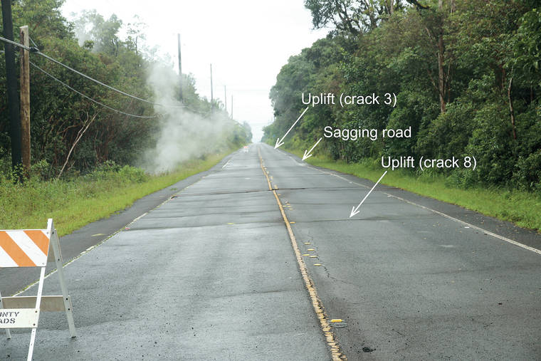
From May 5-7, 2018, when fissures 7-12 were opening farther to the west, or up rift, of Leilani Estates, the pavement on Highway 130 cracked and began to sag. As it did, the area was immediately engulfed in steam and sulfur dioxide gas, so much so you could not see across the road!
A dike is an elongate tabular body (envision a knife blade) that runs parallel to the rift zone. It is fed by magma from deeper within the rift zone core.
As magma rises in a dike, it pushes the surrounding rock apart to make room for magma to reach the surface. This causes the ground directly above the dike to sink and ground on either side of the dike to lift.
As a dike continues moving toward the surface, the sinking, or sagging, above it can progress to form a linear depression with well-defined walls — a feature that geologists call a graben. In 2018, Highway 130 experienced sagging, but a graben did not form across the road.
As soon as Highway 130 sagged and increased heat and gas were observed, HVO field crews documented and numbered 10 major cracks opening across the road. The total extension measured across these 10 cracks was 22 cm (8.6 in) over two days. We were unable to continue measuring crack widths when steel plates were placed on top of them to keep the road open and allow the safe flow of traffic.
Sagging and cracks in the road, as well as increased heat and gas output, meant magma was rising closer to the surface under Highway 130. At the same time, new fissures were opening closer to the highway.
Although steel plates concealed the growing cracks, HVO geologists had other ways to determine what was happening below the road. Sagging ground on Highway 130 and in neighboring properties provided valuable information about where the magma was located.
Theoretical calculations of ground deformation around a dike have been known to volcanologists for decades. Previous modeling shows the horizontal distance between two uplifted sections of ground above a dike is directly related to dike depth below the surface.
On Highway 130, the ground rose slightly in the area of cracks 3 and 8, which were about 100 m (330 ft) apart. Between those two cracks, the ground sagged. Crack 5 was in the middle of the sag, about 50 m (about 165 ft) from crack 8 to the north and crack 3 to the south.
Using the aforementioned model, we can determine how close magma came to reaching the surface where Highway 130 cracked and sagged in 2018. Based on a 100 m (330 ft) distance between uplifts on either side of the down-dropped area, the upper edge of the dike must be only 50-100 m (about 165-330 ft) below the highway!
Thankfully, the portion of the 2018 dike below Highway 130 did not have enough energy to reach the surface.
Now that the uppermost dike is probably solidified, the 2018 magma just below the surface of the highway and neighboring properties will remain frozen in the ground as solid rock.
Volcano activity updates
Kilauea Volcano is not erupting and its USGS Volcano Alert level remains at Normal (https://volcanoes.usgs.gov/vhp/about_alerts.html). Updates for Kilauea are now issued monthly.
Kilauea deformation and seismicity showed no notable changes during the past week. Sulfur dioxide emission rates are low at the summit and below detection limits at Pu‘u ‘O‘o and the lower East Rift Zone. The water pond at the bottom of Halema‘uma‘u continues to slowly expand and deepen.
At or near the 2018 LERZ eruptive fissures, elevated ground temperatures and minor releases of gas (steam, tiny amounts of hydrogen sulfide and carbon dioxide) persist. These are typical post-eruption conditions and are expected to be long-term.
Hazards remain at the LERZ and summit of Kilauea. Closures and warnings in these areas should be heeded. The 2018 lava flows are primarily on private property; be respectful and do not enter or park on private property.
Mauna Loa is not erupting. Its USGS Volcano Alert level remains at Advisory. This alert level does not mean an eruption is imminent or progression to an eruption is certain.
This past week, about 40 small-magnitude earthquakes (all less than M2.5) were detected beneath the upper elevations of Mauna Loa. Deformation measurements show continued summit inflation. Volcanic gas emission and fumarole temperature readings have been slightly elevated from measurements two weeks ago because of maintenance on the instrument sensors last week.
Mauna Loa updates are issued weekly. For more information about the status of the volcano, go to: https://volcanoes.usgs.gov/volcanoes/mauna_loa/status.html
No earthquakes with three or more felt reports occurred in Hawaii this past week.
HVO continues to closely monitor Kilauea and Mauna Loa for any signs of increased activity.
Visit HVO’s website (https://volcanoes.usgs.gov/hvo) for past Volcano Watch articles, Kilauea and Mauna Loa updates, volcano photos, maps, recent earthquake info, and more. Email questions to askHVO@usgs.gov.
Volcano Watch (https://volcanoes.usgs.gov/observatories/hvo/hvo_volcano_watch.html) is a weekly article and activity update written by U.S. Geological Survey Hawaiian Volcano Observatory scientists and affiliates.