Volcano Watch: HVO and collaborators continue seismic surveys across the active volcanoes of Hawaii
The Island of Hawai‘i is one of the most seismically active regions in the world. In the last five years, an average of 600-1200 earthquakes per week have been detected by the USGS Hawaiian Volcano Observatory. This regular rumble of activity across the island can be used to our advantage to assess the hazards that Kilauea and Mauna Loa volcanoes represent.
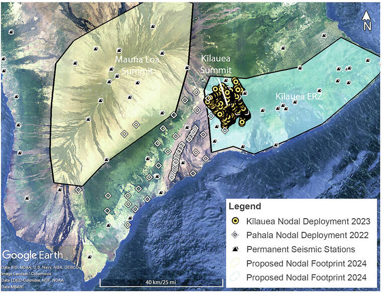
The permanent HVO seismic network consists of nearly 100 stations located across the island. HVO scientists use these stations to monitor the location and character of seismic activity, paying particular attention to signals that might herald migrating magma or potential eruptive activity.
ADVERTISING
As seismic signals move through the ground, they are affected by the structure of the subsurface that they travel through. The presence of magma or fault zones below the ground surface can change how the seismic signals move through these regions. Scientists can take advantage of these altered signals, which are recorded on seismometers at the surface, to create images of where magma is located below.
Using data from only the permanent HVO seismometers provides us with fuzzy pictures of underlying magma storage. As the number of seismometers at the surface is increased, more of the seismic waves traveling through regions of magma storage are recorded. This yields a crisper picture of where magma is located; how big that region of magma storage is; and how it might connect to the surface. The higher resolution the image of magma storage is, the better our understanding of the volcanic hazard a particular volcano represents.
To move beyond the fuzzy images of magma storage at Kilauea and Mauna Loa volcanoes created in past studies using only permanent seismic stations on the Island of Hawai‘i, HVO has purchased a pool of lightweight, portable seismometers that can be easily deployed to target regions of interest. HVO’s seismic nodes were purchased as part of the USGS Additional Supplemental Appropriations for Disaster Relief Act of 2019 (H.R. 2157).
In the summer of 2022, these 80 seismic nodes were deployed across the Pahala region to understand the cause for swarms of deep seismic activity experienced below. Specifically, HVO and collaborators at the University of Hawai‘i at Manoa are testing the hypothesis that magma stored 15–25 miles (24–40 km) below this area migrates laterally through the subsurface (potentially to Kilauea and Mauna Loa), causing the observed high earthquake rates.
In the summer of 2023, HVO scientists and collaborators at the University of Miami and Rensselaer Polytechnic Institute deployed 1800 seismic nodes (both HVO’s nodes and nodes borrowed from the EarthScope Consortium’s instrument pool) across Kilauea summit. The focus of this experiment is to understand where magma is stored beneath Kilauea’s summit and how it migrates to the surface before eruptions.
Currently, HVO and collaborators at ETH Zürich, a public research university, are finalizing locations for about 300 nodes to be deployed in the summer of 2024 across the East Rift Zone of Kilauea. This deployment will collect data near the 2018 Kilauea eruption site, focusing on understanding how much magma is distributed across the East Rift Zone and how it connects to Kilauea’s summit magma reservoir.
Finally, HVO and collaborators at the University of Miami will put out another 50 seismic nodes across Mauna Loa’s summit and rift zones in summer 2024 to gain a greater understanding of how much magma is stored in these regions and how they might be connected to the surface.
Results from all of these seismic node experiments will be interpreted together to form a cohesive view of magma storage below the most active volcanoes on the Island of Hawai‘i. We hope to determine how much magma is possibly stored deep beneath Pahala and whether it connects to Kilauea and/or Mauna Loa. At Kilauea and Mauna Loa, we will determine how much magma is stored beneath the summits and rift zones and the potential pathways to the surface. By better understanding the magma storage regions and their connections, we can better asses the hazards posed by these volcanoes.
Volcano activity updates
Kilauea is not erupting. Its USGS Volcano Alert level is ADVISORY.
Earthquake activity below Kilauea’s summit remains low relative to periods before recent intrusions or eruptions. Less than 200 events were detected over the past week, which is comparable to the week before. Tiltmeters near Sand Hill and Uekahuna bluff continued to record modest inflationary trends over the past week. No unusual activity has been noted along the rift zones.
Mauna Loa is not erupting. Its USGS Volcano Alert Level is at NORMAL.
Webcams show no signs of activity on Mauna Loa. Summit seismicity has remained at low levels over the past month. Ground deformation indicates continuing slow inflation as magma replenishes the reservoir system following the 2022 eruption. SO2 emission rates are at background levels.
One earthquake was reported felt in the Hawaiian Islands during the past week: a M2.4 earthquake 19 km (11 mi) WNW of Kalaoa at 34 km (21 mi) depth on April 5 at 11:30 p.m. HST.
HVO continues to closely monitor Kilauea and Mauna Loa.