Volcano Watch: Did lava flow out of Mauna Loa’s southern caldera in 2022?

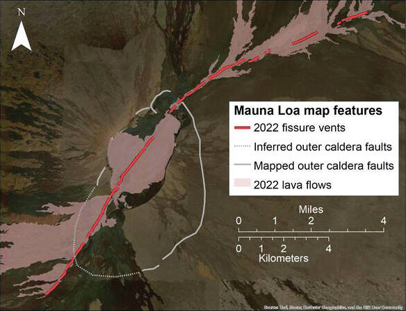
Sources/Usage: Public Domain. Map of the Mauna Loa 2022 eruptive fissures, shown as red lines. Red shaded area indicates lava flows produced during the eruption, around the fissure vent areas. Solid white line indicates mapped outer caldera boundary. White dotted line indicates inferred outer caldera boundary that is buried by historic Mauna Loa lava flows. Fissures on map were documented by C. Parcheta at USGS; lava flow polygons by USGS National Civil Applications Center.
The recent 2022 Mauna Loa eruption began just before midnight, at 11:21 p.m. on November 27. The first caldera floor fissures were visible in webcams; however, the activity propagated south, outside of the view of the webcams, in the initial hours of activity.
The recent 2022 Mauna Loa eruption began just before midnight, at 11:21 p.m. on November 27. The first caldera floor fissures were visible in webcams; however, the activity propagated south, outside of the view of the webcams, in the initial hours of activity.
Official statements from the Hawaiian Volcano Observatory (HVO) noted that initial vents were within the caldera; however, lava flows were reported visible from Kona. Indeed, Kona residents could see lava flows descending the western flank of the volcano and were concerned, feeling that lava was outside of the caldera. In hindsight, it seems appropriate to explain what HVO knew in the first few minutes of the eruption and why Kona residents were able to see the first lava flows.
ADVERTISING
Most people are familiar with Moku‘aweoweo — the inner caldera at Mauna Loa. However, there’s also an outer caldera, which is a geologic term indicating that less obvious mapped faults designate a much larger caldera feature than Moku‘aweoweo.
This is also true at Kilauea. For example, most people think of the Kaluapele as the “giant crater” that Crater Rim Drive mostly encircles, but the outer caldera boundary of Kilauea caldera extends north to the opposite side of Highway 11. When one drives past the entrance to Hawaii Volcanoes National Park, they are driving within the outer caldera of Kilauea!
Mauna Loa’s southern outer caldera is buried under lava flows from the past centuries (see white dashed line on map). Three distinctive pit craters dominate this area from north to south: South Pit in Moku‘aweoweo, Luahohonu, and Luahou. These pit craters are within the outer caldera, and not part of the Southwest Rift Zone (SWRZ).
The western rim of the outer caldera coincides with the inner caldera — we have not found circumferential faults to the west. The white line on map indicates the northern, eastern, and southeastern portions of the outer caldera.
The approximate boundary between the caldera and the SWRZ is where these circumferential cracks cross the rift zone.
Fissures that cross these circumferential cracks would indicate that the eruption is migrating into a rift zone.
Sometimes fissures run right up to the outer caldera boundary and then head in the opposite direction (as during eruptions in 1935, 1942, and 1984).
This is an important concept because HVO stated that initial 2022 fissures were restricted to the summit area.
Yet overnight photographs from Kona showed lava flows descending the western slope — so how was this possible? Shouldn’t the lava be hidden from view by the western topographic edge of the caldera?
HVO’s use of the phrase “summit region” may have caused confusion for some Kona residents who thought HVO was referring to the “inner caldera.” The flows seen from Kona were coming from 3 km (1.8 miles) of fissures in the south outer caldera. When lava is erupting from this area it is visible because there are no major caldera walls obscuring the view of the western flank.
Later mapping revealed that 2 km (1.2 mi) of fissures extended from the outer caldera into the uppermost extent of the SWRZ, with minor lava being emitted from those fissures. In total, the 2022 eruption of Mauna Loa saw 8 km (5 mi) of fissures open across the central and southern outer caldera floor during the night of November 27–28.
By the first eruption overflight at dawn on November 28, all fissures in the inner caldera, southern outer caldera, and the uppermost SWRZ had stopped erupting and were incandescent glowing cracks. A new set of fissures had begun to form on the Northeast Rift Zone (NERZ).
The three lowest elevation fissures were erupting during the initial overflight and named fissure 1–3. Fissure 4 opened two days later, on November 29, 2022.
In total, 17 km (11 mi) of fissures spanned the uppermost SWRZ, the southern and central outer caldera, and the NERZ during the 2022 eruption of Mauna Loa.
Volcano activity updates
Kilauea is not erupting. Its USGS Volcano Alert level is ADVISORY.
Webcams show no signs of active lava in Halema‘uma‘u crater, at the summit of Kilauea in Hawai‘i Volcanoes National Park. Over the past week, summit tiltmeters generally showed mild inflation and slightly elevated seismicity.
The summit sulfur dioxide (SO2) emission rate was most recently measured on April 14, when it totaled 110 tonnes per day.
Mauna Loa is not erupting. Its USGS Volcano Alert Level is at NORMAL.
Webcams show no signs of activity on Mauna Loa. Seismicity remains low.
Summit ground deformation rates show inflation above background levels, but this is not uncommon following eruptions. SO2 emission rates are at background levels.
There was one earthquake with 3 or more felt reports in the Hawaiian Islands during the past week: a M3.6 earthquake 16 km (9 mi) WNW of Hawaiian Ocean View at 44 km (27 mi) depth on April 16 at 7:27 p.m. HST.
HVO continues to closely monitor Kilauea and Mauna Loa.
Please visit HVO’s website for past Volcano Watch articles, Kilauea and Mauna Loa updates, volcano photos, maps, recent earthquake information, and more. Email questions to askHVO@usgs.gov.
Volcano Watch is a weekly article and activity update written by U.S. Geological Survey Hawaiian Volcano Observatory scientists and affiliates.


