Pahala, a town located in the southeast part of the Island of Hawaii, lies above the state’s most seismically active area. In the last 5 years, the average weekly number of earthquakes has increased from about 60 to 600 earthquakes per week.
These frequent earthquakes occur deep beneath the Pahala region at approximately 20 to 40 km (12 to 25 miles) depth. Larger events are regularly felt by residents living both within Pahala and across the island.
In a 2015 study, scientists at USGS located and classified earthquakes in this region into two main groups.
A more continuous seismic tremor, a type of signal often used to trace the movement of magma within a volcanic system, was identified at approximately 40 km (25 miles) depth, both on- and off-shore of the Pahala region. This activity was interpreted as the migration of magma from the deep Hawaiian hot spot to more shallow depths.
Above this deep region of seismic activity, a zone of volcano-tectonic (VT) earthquakes (indicative of rock breaking) was observed extending from this tremor region to deep beneath Kilauea. Based on the linear trend of this seismicity, USGS scientists suggested that this distribution of earthquakes marked a path of magma migration underground from storage below Pahala towards Kilauea summit. However, evidence supporting this hypothesis was limited to one chain of VT events.
A recently released study by seismologists at the California Institute of Technology (CalTech) sheds new light on the processes occurring deep beneath Pahala. These scientists have employed newly developed machine learning (computer systems that analyze large data sets and identify major patterns within the data) to identify a large number of extremely small earthquakes (microseismicity) occurring beneath the Pahala region that were previously uncatalogued by the Hawaiian Volcano Observatory. Such microseismicity is too small to be identified using automated methods typically employed to detect earthquakes.
Many of these events are VT earthquakes located within the zone of deep Pahala seismicity previously identified by USGS scientists. This large number of newly identified VT events outline what appears to be a region of horizontally layered magma storage deep beneath Pahala, called a sill complex.
Further supporting this idea, long period earthquakes (indicative of the movement of fluids such as magma) are seen occurring within these sills. Together, these observations demonstrate that deep seismicity beneath Pahala is consistent with the migration and storage of magma within this sill complex.
The CalTech study also identified a limited number of VT events extending from the sill complex into the region of magma storage beneath Kilauea summit. The authors suggested that this distribution of earthquakes may represent a possible magma pathway from the deep Pahala sill complex into Kilauea’s magma storage reservoir. However, more evidence is needed to support or refute this hypothesis.
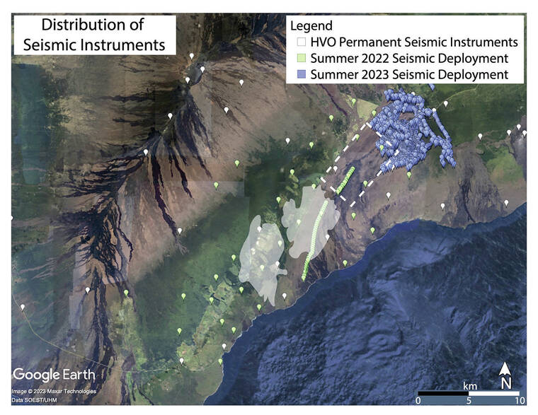
The Hawaiian Volcano Observatory (HVO) is undertaking two large seismic experiments in the region to better understand seismic and volcanic activity in the Pahala and Kilauea regions. In the summer of 2022, 86 temporary seismic instruments were deployed across Pahala to record earthquakes occurring within this region for three months. In the summer of 2023, approximately 1600 temporary seismic instruments are proposed to be deployed across Kilauea summit to record seismic signals for six weeks.
These dense, temporary deployments will record seismic activity across the Kilauea and Pahala regions more accurately than HVO’s permanent network of instruments. Seismologists at HVO will analyze these seismic data to understand whether magma stored within Pahala’s active sill complex is connected to, and therefore a source of magma for Kilauea volcano.
Volcano
activity updates
Kilauea is erupting. Its USGS Volcano Alert level is at WATCH. Kilauea updates are issued daily.
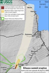
Kilauea volcano’s summit eruption in Halema‘uma‘u crater within Hawai‘i Volcanoes National Park continues, with vents erupting in the central eastern portion of the crater floor. Summit tilt has shown several deflation/inflation trends over the past week. Summit earthquake activity remains low and eruptive tremor (a signal associated with fluid movement) is present. A sulfur dioxide emission rate of 3,500 tonnes per day was measured on January 9. For Kilauea monitoring data, see https://www.usgs.gov/volcanoes/Kilauea/past-week-monitoring-data-Kilauea.
Mauna Loa is not erupting. Its USGS Volcano Alert Level is at ADVISORY. Mauna Loa updates are issued weekly on Thursdays.
Webcams show no signs of activity on Mauna Loa. Seismicity remains low. Ground deformation rates and sulfur dioxide (SO2) emission rates are at background levels. For Mauna Loa monitoring data, see: https://www.usgs.gov/volcanoes/mauna-loa/monitoring-data.
There were three earthquakes with 3 or more felt reports in the Hawaiian Islands during the past week: a M3.1 earthquake 4 km (2 mi) SW of Pahala at 31 km (19 mi) depth on Jan. 9 at 11:23 a.m. HST, a M3.3 earthquake 5 km (3 mi) WSW of Volcano at 0 km (0 mi) depth on Jan. 5 at 3:28 p.m. HST, and a M2.2 earthquake 5 km (3 mi) SW of Volcano at 0 km (0 mi) depth on Jan. 5 at 3:25 p.m. HST.
HVO continues to closely monitor the ongoing eruption at Kilauea, and Mauna Loa.
Please visit HVO’s website for past Volcano Watch articles, Kilauea and Mauna Loa updates, volcano photos, maps, recent earthquake info, and more. Email questions to askHVO@usgs.gov.
Volcano Watch is a weekly article and activity update written by U.S. Geological Survey Hawaiian Volcano Observatory scientists and affiliates.