UPDATE: Governor says ‘standing up the national guard’ part of current lava planning
UPDATED: 12:47 p.m.
Gov. David Ige said this morning that one of the contingency plans being made as lava from Mauna Loa approaches Daniel K. Inouye Highway is activation of the Hawaii National Guard.
ADVERTISING
“We are going to be standing up the national guard and looking at putting together a planning team,” Ige said during a livestreamed press conference. “We’ll be engaged with Hawaii County as the lava flow approaches Daniel K. Inouye Highway to think about what alternatives we may have should the lava overrun the highway.
Ige said that as of now, there’s no “explicit plan at this point” for the role of the guard or how many troops may be deployed. He added the state and county “need to think about what we can do to provide safe traffic flow on DKI Highway.”
“We also know the guard can help supply planning for alternative routes and help with making available bypass routes, if that becomes necessary,” he said. He added the National Guard can also help the county with evacuations of communities, should that become necessary.
Ige said the highway, the island’s main east-west artery “has become more heavily utilized and Big Island residents really count on it.”
“We know that we cannot turn the lava flow … but we certainly will leave no stone unturned to identify options to ensure that we don’t lose access to DKI Highway,” the governor said. “… There is no physical way or technological way to change the course where lava flows.”
Noting that road and bridge repair work on Hawaii Belt Road on the Hamakua Coast has left some trucks that deliver goods across the island too heavy to take that route, Ige said one of the things being considered is greater scrutiny of goods delivery by ocean, including whether to deliver certain items to Hilo or to Kawaihae harbors.
UPDATED: 11:16 a.m.
A viewing area for people to safely watch the lava from Mauna Loa could be set up within the next few days.
During a livestreamed interview today, Mayor Mitch Roth said that the county hopes to open a viewing area near Daniel K. Inouye Highway, although he did not specify where it might be located. He said that the county hoped to set it up today, but realistically will take a few days before it is completed.
Roth said several options for the viewing area have been discussed between the county and other agencies such as the U.S. Geological Survey, the Pohakuloa Training Area, and the state Department of Transportation, but added there remain several safety and legal concerns that need to be addressed.
Roth emphasized that while the lava itself is not directly threatening people right now, parking alongside a busy highway is dangerous. He said that the lava is visible from many places across the island and that lava viewers do not need to go to the highway to see it.
He said Hawaii County police have been issuing $1,000 citations to those parking illegally on the highway.
UPDATED: 10:00 a.m.
Lava is two days away from Daniel K. Inouye Highway at the very earliest.
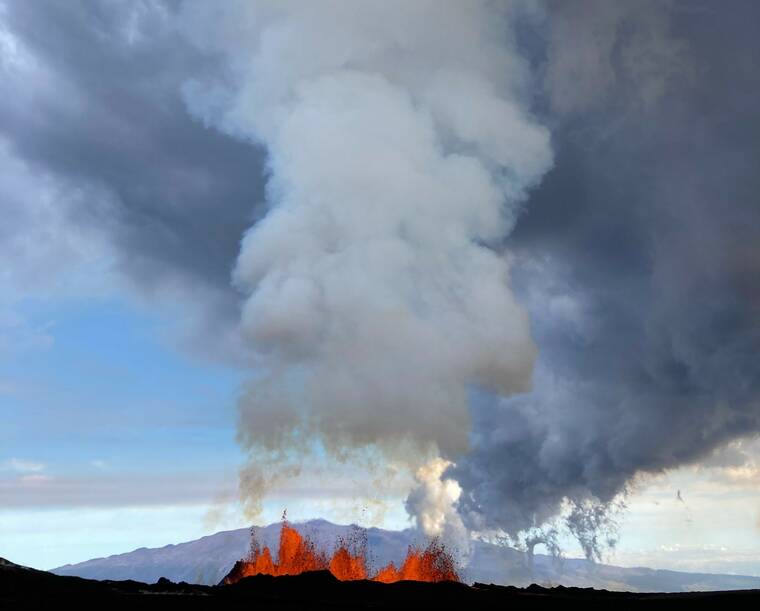
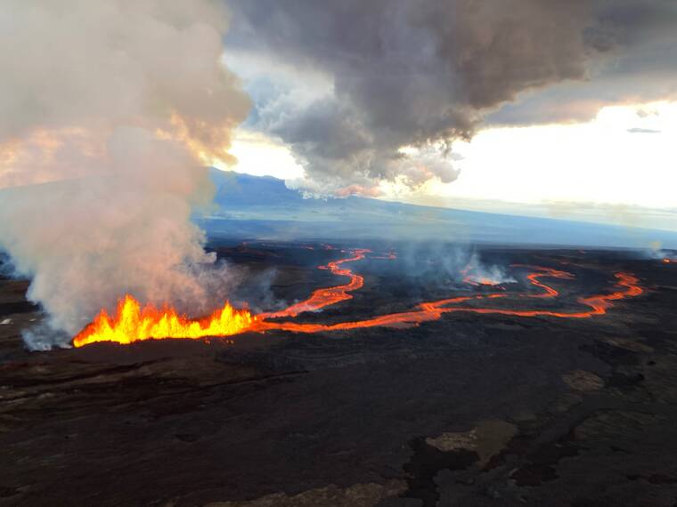
Ken Hon, scientist in charge for the U.S. Geological Survey’s Hawaiian Volcano Observatory, said during a news conference this morning that, based on the Mauna Loa lava flow’s overnight speed of roughly 130 meters per hour, it could cross the remaining 3.6 miles between it and the highway in two days.
However, he emphasized that the lava flow will very likely slow down now that it has reached the flatter land on the island’s saddle area. Hon expects the lava flow to spread out across the saddle and will presumably take longer to reach the highway.
However, Hon said that there is still a “very high probability” that the lava will reach the highway eventually if the eruption continues. The only question, he said, is when it will reach the highway, and where it will cross, but HVO cannot make those predictions until it observes how the lava behaves on the flatter land.
Hawaii County Civil Defense Administrator Talmadge Magno said he has had some preliminary discussions about the possibility of diverting the lava, but added that those conversations have not produced any solid plans.
Hon said diverting an active lava flow is a difficult prospect, saying that the eruption is producing about 10 dump trucks worth of material every second.
Original story
Daniel K. Inouye Highway remains open this morning as lava inches ever closer.
According to a Hawaii County Civil Defense report, the leading edge of the lava flow on Mauna Loa’s northeast flank is still more than three miles away from the Highway, also called Saddle Road.
The highway is still open to traffic in both directions, although parking along the highway is prohibited. Drivers who park along the highway between the 16 and 31 mile markers will be subject to traffic citations and vehicles will be towed.
The state Department of Land andNatural Resources reported that on Tuesday night, the lava flow crossed the Old Kona Highway, a dirt road within the Mauna Loa Forest Reserve.
