Volcano Watch: Ahuʻailaʻau gets a geophysical ‘X-ray’ using ground penetrating radar
In the last few months, Volcano Watch articles have introduced several research projects funded by the Additional Supplemental Disaster Relief Act of 2019 (H.R. 2157). Each of these projects will help scientists better understand how Kilauea volcano works and how the 2018 lower East Rift Zone eruption and collapse of Kilauea summit happened.
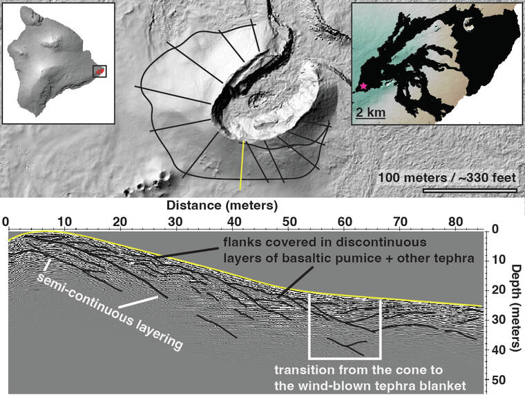
Scientists from the USGS Hawaiian Volcano Observatory and collaborators from the University of South Florida had the unique opportunity to get a peek at the layers inside Ahu‘aila‘au (the cone that formed around fissure 8) with ground penetrating radar over the summer.
ADVERTISING
GPR is a technique that uses small radar pulses to detect objects and changes beneath the ground. When these pulses are transmitted into the ground, they encounter things like faults or the boundary between different lava layers. They hit these obstacles and reflect back towards the surface, where they are captured by a receiving antenna. Unlike medical X-rays, GPR uses low-frequency radio waves no more powerful or harmful than those picked up by household radios. Essentially, GPR allows us to “see” inside of the cone in a way that does not damage it in the long-term.
The transmitter and receiver are attached to a sled and guided along the ground surface and the data are collected in lines. We use different line directions and orientations to tie the lines together so we can get an idea of the layers beneath the surface in 3D.
You may be wondering how deep into the cone we are able to see, and the answer to that question depends on two main things. The first is the wavelength of the energy we transmit with the GPR — the longer the wavelength, the larger the antennae size, and the deeper we can see. The second is the type of ground we run the survey on — very wet clays and soils generally make for poorer survey conditions, whereas dry and hard layers are better. Luckily, things like lava and tephra make for excellent survey conditions!
We were able to image 50 feet (15 meters) into the cone for the Ahu‘aila‘au GPR survey using 100 megahertz antennas. The data collected from GPR surveys are plotted on a “radargram.” Radargrams may look like modern art prints, but to the trained eye of a geophysicist these plots tell us a great deal about what is lurking beneath the surface.
The main purpose of this GPR survey was to help HVO scientists better understand how cinder cones grow. The name “cinder cone” is a bit of a misnomer because features like Ahu‘aila‘au are not built entirely out of uniform piles of cinders. In fact, Ahu‘aila‘au is mostly basaltic pumice!
Most cartoon drawings of cinder cones illustrate their insides like a multi-layered cake that slopes down and outwards from a central high point. Some of these layers are made of cinders (the cake), while others can be bits of lava that were still molten when they landed on the sides of the cone (the icing). As things like the fountain height and the wind direction change, so too do the thickness and location of the eruptive deposits.
The pictured radargram shows that things are a little more complicated and not nearly as delicious as the simple sloped cake model. The upper part of the cone in this area is made mostly of tephra (fragments of lava that travel through the air before being deposited on the ground). These layers are variably thick and are not continuous down the flank of the cone. There is little spatter — globs of lava that stick together when they land — present, as well.
Essentially, we have a very lumpy cake that lacks well defined layers and contains only a small amount of icing. The sections of the cone that bound the opening into the spillway contain a greater amount of spatter than the section shown in the radargram.
Combining our survey results with monitoring data and other geophysical surveys allows us to understand how this prominent feature formed during the three-month-long eruption of Kilauea’s lower East Rift Zone in 2018. We plan to share the results of this Ahu‘aila‘au survey after we complete the data processing.
Volcano activity updates
Kilauea volcano is erupting. Its USGS Volcano Alert level is at WATCH (https://www.usgs.gov/natural-hazards/volcano-hazards/about-alert-levels). Kilauea updates are issued daily.
Over the past week, lava has continued to erupt from the western vent within Halema‘uma‘u crater in Hawaii Volcanoes National Park. Sulfur dioxide emission rates remain elevated and were last measured at approximately 1,300 tonnes per day (t/d) on Sept. 7. Seismicity is elevated but stable, with few earthquakes and ongoing volcanic tremor. Over the past week, summit tiltmeters recorded two deflation-inflation (DI) events. For more information on the current eruption of Kilauea, see https://www.usgs.gov/volcanoes/kilauea/recent-eruption.
Mauna Loa is not erupting and remains at Volcano Alert Level ADVISORY. This alert level does not mean that an eruption is imminent or that progression to an eruption from the current level of unrest is certain. Mauna Loa updates are issued weekly.
This past week, about 158 small-magnitude earthquakes were recorded below the summit and upper elevation flanks of Mauna Loa — the majority of these occurred at shallow depths less than 15 kilometers (9 miles) below sea level. Global Positioning System measurements show low rates of ground deformation over the past week. Gas concentrations and fumarole temperatures at both the summit and at Sulphur Cone on the Southwest Rift Zone have remained stable over the past week. Webcams show no changes to the landscape. For more information on current monitoring of Mauna Loa, see: https://www.usgs.gov/volcanoes/mauna-loa/monitoring.
Two earthquakes were reported felt in the Hawaiian Islands during the past week: a M3.2 earthquake 11 km (7 mi) ENE of Pahala at 31 km (19 mi) depth on September 14 at 4:20 a.m. HST and a M3.3 earthquake 18 km (11 mi) WSW of Hilo at 38 km (24 mi) depth occurred on September 13 at 1:39 a.m. HST.
HVO continues to closely monitor Kilauea’s ongoing eruption and Mauna Loa for any signs of increased activity.
Please visit HVO’s website for past Volcano Watch articles, Kilauea and Mauna Loa updates, volcano photos, maps, recent earthquake info, and more. Email questions to askHVO@usgs.gov.
Volcano Watch is a weekly article and activity update written by U.S. Geological Survey Hawaiian Volcano Observatory scientists and affiliates.