Scientists at the USGS Hawaiian Volcano Observatory largely rely on aerial data collection for making maps of ongoing eruptions at Kilauea. Most commonly, scientists collect a series of overlapping aerial photos (optical or thermal).
A technique called structure-from-motion then uses motion parallax to construct a two-dimensional map or three-dimensional model of the area by matching the same features across multiple images.
HVO’s aerial photography is typically done during helicopter overflights, which are limited by budget, weather, and aircraft availability. Since 2018, small unoccupied aircraft systems (sUAS, or “drones”) have augmented the helicopter overflights to some degree, but they have their own limitations as well. While both of these techniques are excellent for making maps and topographic models, understanding some processes requires even more detailed surveys conducted from the ground.
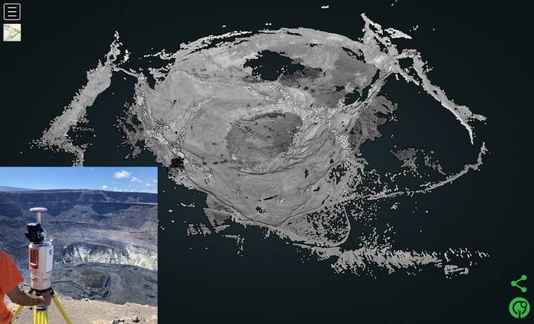
The modern workhorse for ground surveying is terrestrial laser scanning using light detection and ranging (LiDAR) instruments. LiDAR may sound familiar to longtime “Volcano Watch” readers, because the basic technique was described in a November 2020 article that discussed an aerial LiDAR survey at Kilauea. TLS surveys are similar, with a ground-based instrument emitting laser pulses and measuring their return times after reflecting off topographic features.
TLS surveys work best when there is a substantial amount of topographic relief, providing the instrument with good line-of-sight views of distant features. The current lava lake provides an ideal situation because scanning can be done from the crater rim, looking down on the eruptive features. Both the December 2020–May 2021 and September 2021–present eruptions in Halema‘uma‘u crater have been surveyed using TLS LiDAR.
HVO does not have a TLS LiDAR instrument of its own to survey the growing lava lake, so some colleagues have lent a helping hand. The team at the U.S. Army Corps of Engineers’ Cold Regions Research and Engineering Laboratory — who had previously collaborated on a TLS study of the 2008-2018 Halema‘uma‘u lava lake — loaned HVO a TLS LiDAR instrument shortly after the onset of the eruption in December 2020.
CRREL’s LiDAR instrument is a Class 1 laser product, meaning that the laser pulses are safe for the eyes of bystanders and any nearby wildlife (some higher-power instruments require safeguards). For each scan, the LiDAR instrument is set up on survey tripod to rotate through 360 degrees over the course of approximately 15 minutes. These scans produce “point clouds,” which are digital collections of reflection points in three-dimensional space, depicting topographic features.
HVO scientists have completed eight TLS surveys of Halema‘uma‘u since January. Most of these surveys involve visits to the west and south rims of the crater, for at least one scan from each direction. On two occasions, the instrument has been taken to the edge of the eastern down-dropped block within the 2018 collapse crater, for scans at closer range to the lava lake.
The point clouds from HVO’s TLS surveys at Halema‘uma‘u have allowed scientists to build high-resolution digital elevation models of the crater and lava lake. The unmatched accuracy can record detailed topography as small as 5 millimeters (0.2 inches), from a distance up to 2.5 kilometers (1.6 miles) away. In comparison, most aerial photography from HVO helicopter overflights will yield a resolution of approximately 1 meter (yard).
LiDAR also avoids misalignment errors that can warp structure-from-motion models and further decrease their accuracy. This is because LiDAR is a “direct” measurement technique, with the laser pulses actually reflecting back from the measured features. In fact, HVO uses the TLS LiDAR data to help calibrate the structure-from-motion datasets for the Halema‘uma‘u eruptions, improving their accuracy.
HVO hopes to obtain its own TLS LiDAR instrument in the near future, which will open up even more research possibilities using this technology. But in the meantime, we sincerely thank the team at the Cold Regions Research and Engineering Laboratory for their ongoing assistance in studying the eruptive activity at Kilauea.
Volcano
activity updates
Kilauea volcano is erupting. Its USGS Volcano Alert level is at WATCH (https://www.usgs.gov/natural-hazards/volcano-hazards/about-alert-levels). Kilauea updates are issued daily.
Lava continues to erupt from a single vent in the western wall of Halema‘uma‘u crater. All lava activity is confined within Halema‘uma‘u crater in Hawaii Volcanoes National Park. Sulfur dioxide emission rates remain elevated and were measured at approximately 1200 tonnes per day on Nov. 29, 2021. Seismicity is elevated but stable, with few earthquakes and ongoing volcanic tremor.
Summit tiltmeter data has remained relatively flat over the past week. For more information on the current eruption of Kilauea, see Recent Eruption (usgs.gov).
Mauna Loa is not erupting and remains at Volcano Alert Level ADVISORY. This alert level does not mean that an eruption is imminent or that progression to an eruption from the current level of unrest is certain. Mauna Loa updates are issued weekly.
This past week, about 51 small-magnitude earthquakes were recorded below the summit and upper elevation flanks of Mauna Loa — the majority of these occurred at shallow depths less than 10 kilometers (6 miles). A M3.3 earthquake occurred on Mauna Loa’s west flank on December 1. Global Positioning System measurements show no major deformation over the past week. Gas concentrations and fumarole temperatures at both the summit and at Sulphur Cone on the Southwest Rift Zone remain stable. Webcams show no changes to the landscape. For more information on current monitoring of Mauna Loa, see: https://www.usgs.gov/volcanoes/mauna-loa/monitoring.
There were 4 events with 3 or more felt reports in the Hawaiian Islands during the past week: a M2.6 earthquake 22 km (13 mi) SSE of Waimea at 13 km (8 mi) depth on Dec. 1 at 11:29 p.m. HST, a M3.3 earthquake 22 km (13 mi) ENE of Honaunau-Napoopoo at 4 km (2 mi) depth on Dec. 1 at 4:03 p.m. HST, a M3.5 earthquake 19 km (11 mi) ESE of Naalehu at 33 km (20 mi) depth on Nov. 28 at 8:47 p.m. HST, and a M3.6 earthquake 2 km (1 mi) S of Pahala at 32 km (20 mi) depth on Nov. 28 at 5:46 a.m. HST.
HVO continues to closely monitor Kilauea’s ongoing eruption and Mauna Loa for any signs of increased activity.
Please visit HVO’s website for past Volcano Watch articles, Kilauea and Mauna Loa updates, volcano photos, maps, recent earthquake info, and more. Email questions to askHVO@usgs.gov.
Volcano Watch is a weekly article and activity update written by U.S. Geological Survey Hawaiian Volcano Observatory scientists and affiliates.