Halema‘uma‘u crater has undergone repeated changes during the past two centuries. Prior to 1924, the size and shape of the Halema‘uma‘u lava lake changed frequently and lava commonly spilled out across the floor of Kilauea caldera.
After the 1924 collapse of Halema‘uma‘u, the outline of the crater remained amazingly constant until 2018. Ephemeral lava lakes came and went, especially during the 1950s and 1960s, and culminated with the 2008–2018 lava lake.
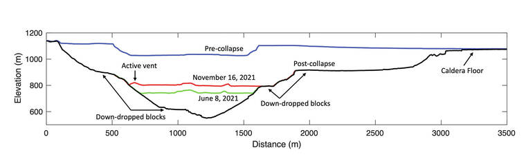
The most significant recent change at Kilauea’s summit occurred in 2018 when the floor of Halema‘uma‘u crater collapsed 500 meters (1,640 ft) and the volume of the caldera increased by almost a cubic kilometer (0.2 cubic miles).
The 2018 eruption and summit collapse of Kilauea ended a period of continuous flank and summit activity that had persisted for decades. A period of quiet uncertainty followed the 2018 events. This ended with the return of eruptive activity at Kilauea’s summit in December 2020. The main characteristic of the new activity is clear, these eruptions are refilling Halema‘uma‘u crater.
Kilauea erupted for the first time since 2018 on Dec. 20, 2020. Lava poured from vents on the walls of Halema‘uma‘u crater into the water lake, which boiled away in a matter of hours. The eruption formed a new lava lake and lasted for five months. The lava lake filled in 226 m (740 ft) of Halema‘uma‘u crater with 41 million cubic meters of lava (54 million cubic yards, or enough to fill 16,000 Olympic-size swimming pools).
Kilauea erupted again on Sept. 29. Vents opened in the center of the older lava lake and on the walls of Halema‘uma‘u. The lava lake began to rise and continue to fill the crater. As of this week, lava is still erupting from a single vent in Halema‘uma‘u and has added a total of 30 million cubic meters (39 million cubic yards) to the volume of the lava lake.
Lava has now refilled Halema‘uma‘u more than half the distance it collapsed in 2018. The lava lake is 282 m (925 ft) deep. But, Halema‘uma‘u is in no danger of filling and overflowing anytime soon. The 71 million cubic meters (93 million cubic yards) of lava that has erupted in the past year account for less than 10 percent of the 1 cubic kilometer volume that collapsed in 2018.
The rising lava lake is slowly covering the irregular terrain left after the caldera floor collapsed in 2018. When the floor collapsed, many areas remained intact as they fell, forming a series of relatively flat surfaces at different elevations within Halema‘uma‘u. HVO scientists call these areas “down-dropped blocks.”
The lowest of these blocks was covered by lava on the first day of the eruption in December 2020. Another down-dropped block on the south side of the crater contains a segment of the old Crater Rim Drive that can be seen from multiple Hawaii Volcanoes National Park viewing areas.
Lava reached the rim of the next lowest down-dropped block to the north and east of the lava lake earlier this month. Last week, lava overflowed onto this block, covering an area about the size of 2 football fields (about a hectare or 2.3 acres). As the lake surface continues to rise, lava will further spread over this block.
Greater volumes of lava are needed for each increase of 1 meter of lake level rise because the width of the crater increases with elevation. At this point, more than 670,000 cubic meters of lava (875,000 cubic yards) needs to erupt to raise the surface 1 m (3 ft) — at the current eruption rate, this takes about 2 days. Lava still has another 100 m (330 ft) to go before it reaches the elevation of the largest down-dropped block (and another 150 m (500 ft) above that to reach the caldera floor). At that elevation, 1.4 million cubic meters of lava (1.8 million cubic yards) will need to erupt to raise the lava surface 1 m (3 ft), twice the current amount.
An important question for HVO scientists is whether this period of refilling is a prelude to an era dominated by summit eruptions, similar to pre-1924 activity, or whether it is the prelude to increased rift zone activity, like what followed the summit lava lakes of the 1950s and 1960s. Either way, change is the one constant at Kilauea.
Volcano
activity updates
Kilauea volcano is erupting. Its USGS Volcano Alert level is at WATCH (https://www.usgs.gov/natural-hazards/volcano-hazards/about-alert-levels). Kilauea updates are issued daily.
Lava continues to erupt from a single vent in the western wall of Halema‘uma‘u crater. All lava activity is confined within Halema‘uma‘u crater in Hawaii Volcanoes National Park. Sulfur dioxide emission rates remain elevated and were measured at approximately 6,400 tonnes per day on Nov. 23. Seismicity is elevated but stable, with few earthquakes and ongoing volcanic tremor. Summit tiltmeter data has remained relatively flat over the past week, with slight deflation over the past few days. For more information on the current eruption of Kilauea, see Recent Eruption (usgs.gov).
Mauna Loa is not erupting and remains at Volcano Alert Level ADVISORY. This alert level does not mean that an eruption is imminent or that progression to an eruption from the current level of unrest is certain. Mauna Loa updates are issued weekly.
This past week, about 83 small-magnitude earthquakes were recorded below the summit and upper elevation flanks of Mauna Loa — the majority of these occurred at shallow depths less than 10 kilometers (6 miles). Global Positioning System measurements show no major deformation over the past week. Gas concentrations and fumarole temperatures at both the summit and at Sulphur Cone on the Southwest Rift Zone remain stable. Webcams show no changes to the landscape. For more information on current monitoring of Mauna Loa, see: https://www.usgs.gov/volcanoes/mauna-loa/monitoring.
There were 6 events with 3 or more felt reports in the Hawaiian Islands during the past week: a M3.1 earthquake 8 km (4 mi) ENE of Kalaoa at 16 km (10 mi) depth on Nov. 24 at 7:45 a.m. HST, a M3.2 earthquake 3 km (2 mi) S of Pahala at 35 km (22 mi) depth on Nov. 22 at 11:18 p.m. HST, a M3.1 earthquake 4 km (2 mi) S of Pahala at 36 km (22 mi) depth on Nov. 22 at 10:31 a.m. HST, a M3.5 earthquake 6 km (3 mi) ENE of Pahala at 32 km (20 mi) depth on Nov. 21 at 8:00 a.m. HST, a M3.3 earthquake 6 km (3 mi) E of Pahala at 32 km (20 mi) depth on Nov. 20 at 11:03 p.m. HST, and a M3.2 earthquake 6 km (3 mi) SSW of Pahala at 34 km (21 mi) depth on Nov. 17 at 5:33 p.m. HST.
HVO continues to closely monitor Kilauea’s ongoing eruption and Mauna Loa for any signs of increased activity.
Please visit HVO’s website for past Volcano Watch articles, Kilauea and Mauna Loa updates, volcano photos, maps, recent earthquake info, and more. Email questions to askHVO@usgs.gov.
Volcano Watch is a weekly article and activity update written by U.S. Geological Survey Hawaiian Volcano Observatory scientists and affiliates.