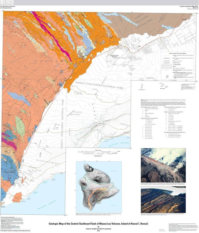
The recently published “Geologic map of the central-southeast flank of Mauna Loa volcano” is the culmination of years of field work by the U.S. Geological Survey. This updated map supersedes the “Geologic Map of the Island of Hawai‘i” (1996) and the “Geologic Map of the State of Hawai‘i” for the Mauna Loa region.
The new map encompasses 195 square miles (506 sq km) of the southeast flank of Mauna Loa — an area equivalent to the islands of Kahoolawe and Lanai combined! — and ranges from an elevation of 10,350 feet (3,155 m) to sea level.
It includes areas adjacent to and downslope of Mauna Loa’s Northeast Rift Zone, as well as regions east and directly downslope of Moku‘aweoweo, the volcano’s summit caldera. From high on Mauna Loa’s east flank, the mapped area extends toward Hawaii Volcanoes National Park and the community of Volcano (population of approximately 2,000 residents) in the northeast. At the southern boundary of the mapped area is Punaluu Bay.
Lava flows from the middle and upper reaches of the Northeast Rift Zone dominate the northern part of the map, comprising about 40% of the total area. The map’s southern portion contains flows from the upper Southwest Rift Zone that make up about 2% of the total area. Lava from the upper reaches of both rift zones generally forms narrow flow lobes.
The remaining 58% of the map (center area) consists of lava flows from the summit of Mauna Loa. In contrast to flows from the rift zones, lava flows derived from the summit caldera form voluminous, broad expansive sheets of pahoehoe that cover large areas. ‘A‘a flows occur in this area but are inconsequential when compared to the pahoehoe flows.
Mauna Loa, the largest active volcano on Earth, is known to have erupted 33 times since written descriptions became available in 1832. Some eruptions were preceded by only brief seismic unrest, while others followed several months to a year of increased seismicity.
Most Mauna Loa eruptions begin in its summit area at or above the 12,000-ft (3,658-m) elevation. The central-southeast flank has not been the source of any volcanic activity, although two historical eruptions that began along the Northeast Rift Zone sent flows into the mapped region in 1880 and 1984.
The map shows the distribution of 96 eruptive units (flows) separated into 15 age groups ranging from more than 30,000 years before present to 1984. The map also shows the relationships between volcanic and surficial sedimentary deposits. The color scheme is based on the ages of the volcanic deposits. Warm colors (red, pink and orange) represent recent epochs of time while cool colors (blue and purple) represent older deposits.
From the geologic record, we can deduce several generalized facts about the geologic history of Mauna Loa’s southeast flank.
For example, geologic mapping and radiocarbon ages of the flows indicate there was a period of sustained summit activity from about 2,000 to 1,300 years before present. Lava flows of this age cover more than 75% of the area directly downslope from the summit in this new map.
There are a few kipuka of older flows, but they are limited in number and extent. This means Mauna Loa experienced approximately 700 years of nearly continuous activity, significantly longer than the 35-year-long eruption that occurred on Kilauea from 1983-2018!
Other interesting tidbits gleaned from the new map include the following:
• About 55% of the map area is covered by layers of volcanic ash of varying thicknesses, which indicate explosive volcanic eruptions. The ages and origins of these ash deposits still need to be determined.
• A historically active tectonic zone on the southeast flank of Mauna Loa, known as the Ka‘oiki Fault Zone, is the site of some recent large tectonic earthquakes. In 1983, a magnitude-6.6 earthquake on the Ka‘oiki Fault Zone preceded Mauna Loa’s 1984 eruption. Earthquakes greater than magnitude-5.5 also occurred there in 1974, 1963 and 1962.
The “Geologic map of the central-southeast flank of Mauna Loa volcano” provides fundamental information on the long-term eruptive behavior of Mauna Loa volcano. It also offers valuable base information on which collaborative studies in geology and biology can be launched.
The map can be viewed or freely downloaded from the USGS Publications website at https://pubs.er.usgs.gov/publication/sim2932B.
Volcano activity updates
Kilauea Volcano is not erupting and its USGS Volcano Alert level remains at Normal (https://volcanoes.usgs.gov/vhp/about_alerts.html). Updates for Kilauea are now issued monthly.
Kilauea monitoring data continue to show steady rates of seismicity and ground deformation, low rates of sulfur dioxide emission and only minor geologic changes since the end of eruptive activity in September 2018. Water continues to pond at the bottom of Halema‘uma‘u inside the summit caldera. More info: https://volcanoes.usgs.gov/volcanoes/kilauea/status.html.
Hazards remain at the lower East Rift Zone and summit of Kilauea. Closures and warnings in these areas should be heeded. The 2018 lava flows are primarily on private property; please be respectful and do not enter or park on private property.
Mauna Loa is not erupting. Its USGS Volcano Alert level remains at Advisory. This alert level does not mean an eruption is imminent or progression to an eruption is certain.
This past week, about 40 small-magnitude earthquakes (all less than M2.5) were detected beneath the upper elevations of Mauna Loa. Deformation measurements show continued summit inflation. Volcanic gas emission and fumarole temperature readings have been slightly elevated from measurements several weeks ago because of maintenance on the instrument sensors in mid-September.
Mauna Loa updates are issued weekly. More info: https://volcanoes.usgs.gov/volcanoes/mauna_loa/status.html.
Two earthquakes with three or more felt reports occurred in Hawaii this past week: a magnitude-2.2 quake 8 km (5 mi) northwest of Honokaa at 25 km (16 mi) depth at 12:06 a.m. Sept. 29 and a magnitude-3.1 quake 11 km (7 mi) west of Pahala at 9 km (6 mi) depth at 10:17 p.m. Sept. 28.
HVO continues to closely monitor Kilauea and Mauna Loa for any signs of increased activity.
Visit HVO’s website (https://volcanoes.usgs.gov/hvo) for past Volcano Watch articles, Kilauea and Mauna Loa updates, volcano photos, maps, recent earthquake info and more. Email questions to askHVO@usgs.gov.
Volcano Watch (https://volcanoes.usgs.gov/observatories/hvo/hvo_volcano_watch.html) is a weekly article and activity update written by U.S. Geological Survey Hawaiian Volcano Observatory scientists and affiliates.