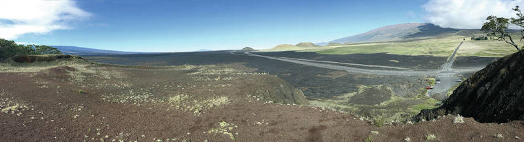
In ongoing media coverage of demonstrations at the base of the Maunakea Access Road, many hundreds of people can be seen standing on a black lava flow that surrounds the Pu‘uhuluhulu Native Tree Sanctuary adjacent to Daniel K. Inouye Highway.
That same lava flow continues on the other side of the highway, which traverses the saddle between Mauna Loa and Maunakea.
The eruption that produced the lava flow started at the summit crater of Mauna Loa on Nov. 21, 1935, and quickly progressed into the volcano’s upper Northeast Rift Zone. From there, lava advanced to the west, away from Hilo, the largest city on the island.
On Nov. 27, another vent opened lower on the north flank of Mauna Loa from which an additional lava flow quickly advanced to the north. Within 10 days, the flow stalled at the base of Maunakea but remained active. This lava was known as the Humu‘ula flow.
The lava flow worried residents of Hilo for a time because, after ponding and likely inflating behind Pu‘uhuluhulu, it suddenly broke out toward the city at alarming rates of about 2-3 km (1.5-2 miles) per day for nearly a week in late December.
Thomas Jaggar, who was director of the Hawaiian Volcano Observatory at the time, had been warning island residents about the potential destruction by future lava flows during the year prior. When it appeared the 1935 Humu‘ula flow was headed toward Hilo, he wanted to divert the lava by bombing the flow and requested Army airplanes from Oahu to do the job.
The bombing operation launched from the Hilo airport on Friday, Dec. 27, 1935. After the military planes dropped bombs near the eruptive vent, the flow appeared to slow. A few days later, Jaggar declared success, and most Hilo residents, relieved by his words, went back to their normal tasks.
But not everyone was happy.
On Dec. 28, an article on the front page of the Hilo Tribune Herald was titled, “Pele Angry! Old Natives express fear of bombing.” The article went on to quote several Hawaiians.
“Pele should not be disturbed. This bombing is a folly. It will do more harm than good. If Pele makes up her mind to come to Hilo it is not for man to dissuade her by artificial methods. She cannot be stopped that way.”
Harry Keliihoomalu, a longtime Puna resident, went to the Hilo airfield to warn the pilots of Pele’s anger and then visited the newspaper’s office to voice his objections.
“Why don’t they leave Pele alone? They shouldn’t interfere with the flow. If Pele decides to flow to Hilo, there’s nothing that they can do to stop her.”
Eben “Rawhide Ben” Low, kamaaina resident and one-time cowboy and rodeo star, agreed.
“Dropping a bomb into the Mauna Loa lava flow is like throwing a peanut into the middle of the Pacific Ocean, for all the good it will do.”
Was the bombing successful? Jaggar was the only geologist to claim so.
Jaggar’s boss, Edward G. Wingate, superintendent of Hawaii National Park (as it was called then), was non-committal.
Prior to the actual bombing, Wingate was skeptical of the use of airplanes and arranged transport of the explosives to the vent by land. But after Jaggar exclaimed the bombing a success, Wingate simply deferred to Jaggar’s claim.
Contemporary geologists were unconvinced, and, in more recent times, studies of the 1935 flow show that its slowing was probably coincident with, rather than caused by, the bombing. In hindsight, one could conclude that the bombing was indeed a folly.
Volcano activity updates
Kilauea Volcano is not erupting and its USGS Volcano Alert level remains at Normal. For definitions of USGS Volcano Alert Levels, visit https://volcanoes.usgs.gov/vhp/about_alerts.html.
Monitoring data have shown no significant changes in Kilauea activity during the past week. Rates of seismicity across the volcano remain low.
Kilauea summit deformation has been consistent with slow magma accumulation within the shallow portion of the summit magma system, but gas measurements have not indicated significant shallowing of magma.
Kilauea East Rift Zone deformation continues to show motions consistent with slowed refilling of the deep magmatic reservoir in the broad region between Pu‘u ‘O‘o and Highway 130.
The south flank of Kilauea continues to creep seaward following the May 4, 2018, magnitude-6.9 earthquake near Kalapana. Elevated rates of motion on faults after a large earthquake are common and no cause for alarm.
Sulfur dioxide emission rates are low at the summit and below detection limits at Pu‘u ‘O‘o and the Lower East Rift Zone.
Hazards remain at the lower ERZ and summit of Kilauea. Residents and visitors near the 2018 fissures, lava flows and summit collapse area should heed Hawaii County Civil Defense and Hawaii Volcanoes National Park closures and warnings. The 2018 lava flows are primarily on private property, and people are asked to be respectful and not enter or park on private property.
Mauna Loa is not erupting. Its USGS Volcano Alert level remains at Advisory because earthquake and ground deformation rates at the volcano continue to exceed long-term background levels. This alert level does not mean an eruption is imminent or that progression to an eruption is certain. A similar increase in activity occurred between 2014 and 2018 and no eruption occurred.
This past week, approximately 75 small-magnitude earthquakes (most less than M2.0) occurred beneath the summit and upper Southwest Rift Zone.
Deformation measurements show continued summit inflation, suggestive of recharge of the volcano’s shallow magma storage system.
No significant changes in volcanic gas release on the Southwest Rift Zone were measured, and fumarole temperatures there and at the summit remain unchanged.
For more info about the status of Mauna Loa, visit https://volcanoes.usgs.gov/volcanoes/mauna_loa/status.html.
No earthquakes with three or more felt reports occurred in Hawaii this past week.
HVO continues to closely monitor Kilauea and Mauna Loa for any signs of increased activity.
Visit HVO’s website (https://volcanoes.usgs.gov/hvo) for past Volcano Watch articles, Kilauea and Mauna Loa updates, volcano photos, maps, recent earthquake info, and more. Email questions to askHVO@usgs.gov.
Volcano Watch (https://volcanoes.usgs.gov/observatories/hvo/hvo_volcano_watch.html) is a weekly article and activity update written by U.S. Geological Survey Hawaiian Volcano Observatory scientists and affiliates.