CORRECTION: The U.S. Geological Survey said on Twitter the high levels of sulfur dioxide, between 35,000 and 45,000 tons per day, is occurring at the lower East Rift Zone and not at the volcano’s summit. The HVO website noted: “Sulfur dioxide emissions from the volcano’s summit have dropped to levels that are about half those measured prior to the onset of the current episode of eruptive activity.” The Tribune-Herald regrets the error.
Lava from Kilauea volcano’s lower East Rift Zone eruption destroyed more homes Monday in Kapoho and additional homes are expected to be lost to the flow today, according to the county.
“There were six to seven houses that burned yesterday with three or four more ready to go today,” Janet Snyder, Mayor Harry Kim’s spokeswoman said this morning.
The official tally of homes destroyed by lava remains at 668. The actual number of homes lost is higher, and the county continues to reconcile flyover photos with county tax map records to update the official count.
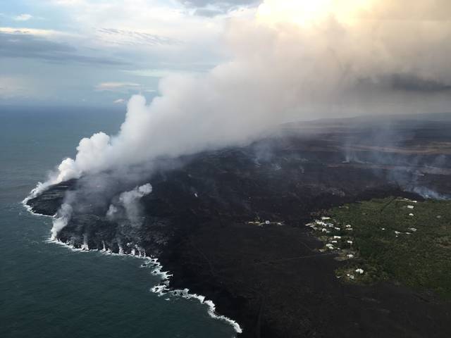
Hawaiian Volcano Observatory reports that fissure No. 8 remains quite active and the flow front is producing a broad entry along the shoreline.
According to Snyder, HVO geophysicist Jim Kauahikaua said the flow “looks like rapids,” and there were breakout chunks of hardened lava, known as lava boats, that interrupted the flow somewhat at Kapoho.
“There was some overflow to the north area. Now the flow is reoccupying the channel,” Snyder relayed.
Fissure No. 22 also remains active. Snyder described it as “smoking, with a very small flow going about 800 feet.
Deanna Marks of the National Weather Service also spoke at this morning’s briefing to emergency workers at Hawaii County Civil Defense headquarters in Hilo, and said there were about 1,200 lightning strikes between 7 a.m. and 2 p.m. during Monday’s thunderstorm.
“We got calls galore from people yesterday,” Snyder said.
Marks, according to Snyder, said yesterday’s localized thunderstorm was caused by “a combination of no wind, moisture from laze plumes, low pressure aloft and a heat source from the lava.”
“The lighting strikes were focused almost directly over fissure 8 and it followed the lava track down to Kapoho,” Snyder said.
Snyder quoted Mayor Kim as saying, “This is a phenomenon we’ve never seen.”
“Things sort of dissipated when the trades came back this morning,” Snyder said. “Now we have almost due northeast winds 10 to 15 miles per hour. Yesterday, we saw heat-induced whirlwinds. They picked up all kinds of stuff, like Pele’s hair, and spit some lava around.”
A summit explosion occurred at 2:17 a.m. today, creating energy the equivalent of a magnitude-5.1 earthquake.
Snyder said the U.S. Geological Survey “is looking at gas emission rates” — especially those of sulfur dioxide (SO2) — at the summit of Kilauea
“The rates of SO2 seem to be increasing,” she said. “They’re looking at emissions of 35,000 to 40,000 tons, which is 10 times what it was in April. … Emissions in the lower East Rift Zone are at a quite high level, as well.
‘They believe that the increase of SO2 is directly proportional to the eruption level and to the subsidence rates at the summit.”
Highway 130 was reopened this morning at 8 a.m. Kamaili Road is open to residents only and checkpoints remain at both ends, at Highways 130 and 137. Highway 137 remains open from Highway 130 north to Kamaili, also known as Opihikao Road.
MacKenzie State Recreation Area and the new lava flow areas remain closed.
Email John Burnett at jburnett@hawaiitribune-herald.com.