Federal aid for people affected by the Kilauea eruption might be approved soon after Gov. David Ige signed a request for such assistance Wednesday.
The letter, addressed to Jeffrey Byard, associate administrator for the Federal Emergency Management Agency’s office of response and recovery, requests assistance from the federal government’s individual assistance programs, citing the economic impacts of the eruption on the island in general and the lower Puna region in particular.
The letter specifically names six programs, which Jodi Leong, a spokeswoman for Ige’s office, said are all of the federal government’s individual assistance programs.
The programs include:
• Individuals and Households Program, which the letter describes as “necessary to help survivors get back on their feet.”
• Transitional Sheltering Assistance Program, which will help fill the need for short-term sheltering.
• Crisis Counseling Assistance and Training Program, providing much-needed mental health support for evacuees.
• Disaster Unemployment Assistance.
• Disaster Case Management, which will provide evacuees with individualized recovery plans.
• Disaster Legal Services, which will assist evacuees with insurance, landlords and other legal issues.
Ige’s letter goes into significant detail in describing the economic impact the eruption has had on lower Puna, as well as broader impacts on the island as a whole.
An estimated 455 homes have been destroyed so far, according to the letter, with 192 of those confirmed to be primary dwellings. Some 2,700 people have been ordered to evacuate, and shelters have seen 5,417 overnight stays as of June 6.
Hawaii County Civil Defense reported an estimated 450-500 people were at the shelters during the most recent count.
Meanwhile, 39 vacation rentals were reported destroyed, resulting in an estimated $37 million in damages.
To date, 28 farmers have reported a complete loss of operations, representing a loss of $14 million, while volcanic gases downwind of the flow are impeding the harvest of cash crops such as macadamia nuts and coffee beans.
Ige’s letter also addresses the effect of the eruption on the island’s tourism industry. The temporary suspension of Norwegian Cruise Lines’ port calls in Hilo and Kailua-Kona cost local businesses an estimated $750,000 per visit, while the ongoing closure of Hawaii Volcanoes National Park has cost the island $455,000 in visitor spending per day.
FEMA might take as much as a week to respond to Ige’s request, Leong said. In the meantime, FEMA’s incident management assistance team hopes to establish a Disaster Assistance Center on the island by the end of the week.
County spokeswoman Janet Snyder said the center would serve as a clearinghouse for applications for federal assistance, as well as a location to connect evacuees with agencies such as the Red Cross and other county and state programs.
The center would be located at the Keaau High School gymnasium, where it would be open seven days a week. However, Snyder said a presidential disaster declaration is required before the center could be opened.
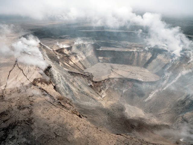
Hawaii Volcanoes National Park spokeswoman Jessica Ferracane said some of the park’s infrastructure has sustained considerable damage from frequent earthquakes emanating from the summit.
Jaggar Museum, located near Halema‘uma‘u crater, displayed some cracks on its ceiling, Ferracane said, while the museum’s deck overlooking the crater “doesn’t look like it’s going to be there much longer” because of substantial cracking.
Ferracane does not know how long it will take to assess and repair the damage at the park, even after the area becomes safe. The summit is rocked by hundreds of minor temblors each day, so any assessment would be rendered obsolete after another day of quakes.
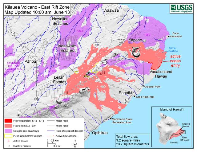
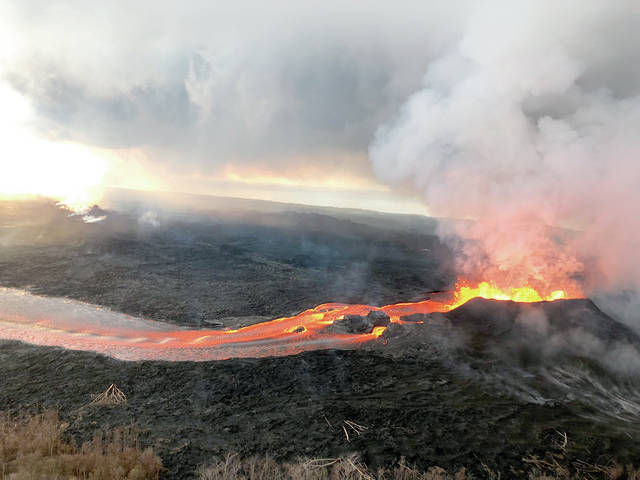
Hawaiian Volcano Observatory geologist Mike Zoeller said the ocean entry of the lava flow in Kapoho now covers approximately 260 acres. He added that in addition to fissure 8 — which has driven the vast majority of the lava flow for the past weeks — fissures 16 and 18 produced some flows Wednesday, although they remained entirely within the existing 5,940-acre — or approximately 9-square-mile — lava field.
Hawaii Police Department Capt. Samuel Jelsma, Puna District commander, said there have been reports of looting at the Kapoho remnant, where approximately two dozen homes remain isolated from the rest of the area, untouched by lava. These reports, Jelsma said, were unconfirmed and unsubstantial.
Jelsma said the only way to access the Kapoho remnant would be by sea, using a nearby boat ramp in Pohoiki. While the boat ramp is technically closed during the evacuation, Jelsma said he is aware that residents have been using it since the evacuation began.
Police have not been keeping track of residents remaining in the Kapoho remnant, Jelsma said, noting that staying within the area would incur a citation.
Rob Ballard, National Weather Service meteorologist, said the trade wind patterns are weakening, which might lead to vog, ash and gas drifting northward toward more densely populated areas. Residents are advised to remain cautious and check the Environmental Protection Agency’s website for updated maps of air quality around the island.
The state Department of Health announced Wednesday that it would install 10 new monitoring stations around the Big Island to analyze airborne particles and sulfur dioxide. While the locations of the new stations have not been determined, they will join five existing stations in Hilo, Mountain View, Pahala, Ocean View and Kona.
The Kalapana Solid Waste Transfer Station, which has been closed because of road conditions on Highway 130, will resume limited service. The station will be open from 6 a.m.-6 p.m. each Saturday beginning this weekend.
Email Michael Brestovansky at mbrestovansky@hawaiitribune-herald.com.