Tropical Storm Octave not expected to affect Hawaii
Tropical Storm Octave, a cyclone in the Eastern Pacific, is moving westward toward the Central Pacific basin, but forecasters don’t think the storm is going to pose a threat to Hawaii.
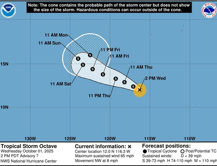
As of 11 a.m. today, the center of Octave was about 860 miles south-southwest of the southern tip of the Baja California peninsula in Mexico, packing maximum sustained winds of 65 mph with locally higher gusts and moving northwesterly at 8 mph.
ADVERTISING
“It’s not expected to impact the islands, at all. In fact, the current forecast doesn’t even have it going west of 125 (degrees) West longitude, which is very far away,” said Thomas Vaughan, a National Weather Service in Honolulu. That’s 15 degrees east of the Central Pacific, with an eastern boundary of 140 degrees West longitude and a western boundary of 180 degrees West.
According to the National Hurricane Center in Miami, tropical-storm-force winds of 39 mph or stronger extend outward up to 60 miles from the storm’s center, and little change in strength is forecast during the next 48 hours.
“It is forecast to remain a tropical storm throughout the weekend and into early next week,” Vaughan said. “And the track doesn’t really move all that much. It moves northwest into Saturday, then more north-northeast by Sunday and Monday.
“Again, we’re forecasting no impact to Hawaii. We’re pretty confident. It’s really, really far away.”
There are no coastal watches, warnings or advisories in currently in effect for Hawaii, and the NWS Hawaii website states, “Tropical cyclone activity is not expected during the next seven days between 140 West and 180.”
Email John Burnett at jburnett@hawaiitribune-herald.com.