The last eruption of Mauna Loa occurred in 1984 and began in a style typical of the volcano. At 10:55 p.m. on March 24, 1984, the rate of earthquakes under Mauna Loa started to rapidly pick up. While rates of earthquakes were already above normal, they quickly rose to 2-3 earthquakes per minute.
By 11:30 p.m., strong seismic tremor had begun, indicating that magma was moving underground and getting close to the surface. The eruption began at Mauna Loa’s summit at 1:30 a.m. on March 25.
The rapid onset of extreme unrest leading to eruption in 1984 is typical of the Mauna Loa eruptions that have been observed in the last two centuries. In addition to rapid onset, eruptions that migrate down either of Mauna Loa’s rift zones tend to be high volume and resulting lava flows can move quickly from their eruptive vents downslope toward the ocean. As described in a March 11, 2022, “Volcano Watch” article, lava flows moving down the steep slopes of South Kona can reach the ocean as soon as 3-4 hours after the start of a rift eruption. The combination of rapid onset, large lava volumes, and fast lava flows can make Mauna Loa eruptions particularly hazardous.
The technology we use to monitor volcanoes has changed a lot since 1984. Paper seismograms, hand-collected survey data, and visual observations have given way to digital broadband seismic data, continuous GPS measurements, and a network of webcams. This means we have a lot more detail about Mauna Loa’s current period of unrest than has ever been possible before. Nonetheless, it is still possible for the situation to change rapidly and it is difficult to forecast when that might happen.
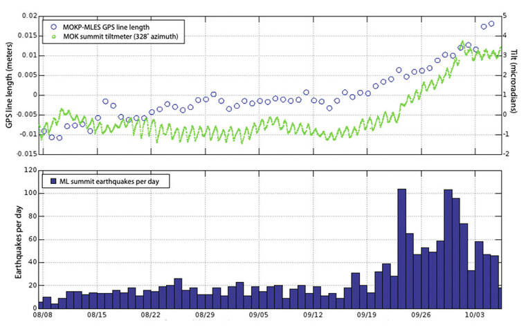
Mauna Loa’s current episode of unrest began in late 2014 with an increase in the rates of inflationary deformation and seismicity. These rates waned in 2017-2018, but began increasing again in 2019 and have remained somewhat steady since then, with earthquake rates of about 20 per day. A noticeable seismic swarm occurred from late January through mid-April 2021 and was accompanied by changes by ground surface tilt recorded by a summit tiltmeter. This was an unprecedented observation that indicated magma had been getting closer to the surface. Another short swarm and tilt event was observed in early August 2022.
The current and ongoing swarm began on Sept. 22 and marked the start of a persistent increase in earthquake rate at Mauna Loa’s summit. It rose from about 20 per day to 40-50 per day, with two days getting as high as 100 per day. Shallow (less than about 2 miles or 3 kilometers depth) opening of magma pathways has also been detected as an inflationary tilt event. However, the bulk of Mauna Loa’s deformation is still due to deeper processes (greater than about 2 miles or 3 kilometers depth) that have been occurring since 2019.
Other signals, such as seismic tremor, that would indicate that an eruption is imminent, have not been observed. However, due to the sustained high level of earthquakes, the Hawaiian Volcano Observatory (HVO) has begun issuing daily updates on Mauna Loa’s status that are available on the USGS website (https://www.usgs.gov/volcanoes/mauna-loa/volcano-updates).
This uptick in activity is a good reminder to be prepared for a volcanic eruption, whether you live on the flanks of Mauna Loa or anywhere else on the Island of Hawaii.
The steps to be prepared for a volcanic eruption are the same as for many other hazards and is part of “All Hazards” preparedness.
It includes putting together a “go bag” with essentials in the case of quick evacuation, as well as a communication plan among your family members, and knowing how to get updated emergency information. More information is available in a March 11, 2021, “Volcano Watch” article that focused on lava flow hazards from Mauna Loa (https://on.doi.gov/3yrXLwn).
Additionally, Hawaii County Civil Defense has resources on their website (https://www.hawaiicounty.gov/departments/civil-defense/emergency-preparedness) to help you create an “All Hazards” plan for your family.
Volcano
activity updates
Kilauea volcano is erupting. Its USGS Volcano Alert level is at WATCH (https://www.usgs.gov/natural-hazards/volcano-hazards/about-alert-levels). Kilauea updates are issued daily.
Over the past week, lava has continued to erupt from the western vent within Halema‘uma‘u crater in Hawaii Volcanoes National Park. Sulfur dioxide emission rates remain elevated and were last measured at approximately 1,800 tonnes per day (t/d) on September 30.
Seismicity is elevated but stable, with few earthquakes and ongoing volcanic tremor. Over the past week, summit tiltmeters recorded several minor deflation-inflation (DI) events.
Mauna Loa is not erupting and remains at Volcano Alert Level ADVISORY. This alert level does not mean that an eruption is imminent or that progression to an eruption from the current level of unrest is certain. Mauna Loa updates are issued daily.
This past week, about 430 small-magnitude earthquakes were recorded below the summit and upper elevation flanks of Mauna Loa — the majority of these occurred at shallow depths less than 15 kilometers (9 miles) below sea level. Global Positioning System measurements show continued ground deformation consistent with inflation of a magma chamber beneath the summit. Gas concentrations and fumarole temperatures at both the summit and at Sulphur Cone on the Southwest Rift Zone have remained stable over the past week.
Webcams show no changes to the landscape. For more information on current monitoring of Mauna Loa, see: https://www.usgs.gov/volcanoes/mauna-loa/monitoring.
One earthquake was reported felt in the Hawaiian Islands during the past week: a M3.4 earthquake 10 km (6 mi) NE of Pahala at 32 km (20 mi) depth on Oct. 4 at 10:38 p.m. HST.
Email questions to askHVO@usgs.gov.