Why hasn’t LA seen a big San Andreas quake recently? Researchers find a clue
It’s a riddle that has both blessed California and still raises worries for the future: Why hasn’t L.A. seen a big San Andreas earthquake in generations? And what does that mean when it does come?
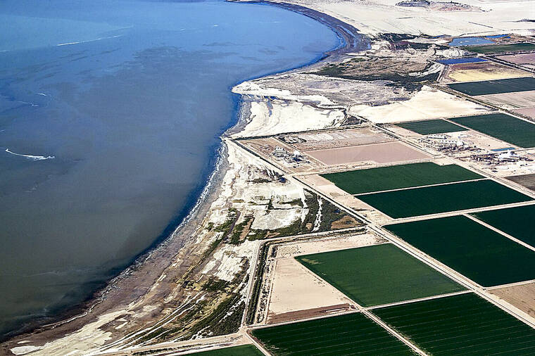
A new study provides a possible answer — the drying Salton Sea, about 150 miles southeast of L.A., and the lack of sudden, major floodwaters funneling into it since it formed more than a century ago.
ADVERTISING
But one thing is certain. The drought of earthquakes on the San Andreas fault will not last. A drying Salton Sea may be helping delay the next Big One, but that could result in a more powerful quake when it does strike.
A study published Wednesday in the journal Nature by scientists at San Diego State University and the Scripps Institution of Oceanography at UC San Diego aimed to help explain why the southernmost tip of the San Andreas fault, close to the Mexican border, hasn’t had an earthquake of a magnitude 7 or greater in about 300 years.
That’s an unusually long gap. Other sections of the San Andreas have ruptured more recently. A section between Monterey County and San Bernardino County ruptured 166 years ago, and another portion ruptured in the great San Francisco earthquake 117 years ago.
In this southernmost section of the San Andreas, there have been seven major earthquakes between the 10th and 18th centuries. Some were probably separated by only a 40- or 50-year gap. For others, the gaps were probably as long as 280 years.
But it’s been about three centuries — sometime between 1721 and 1731 — since a temblor that was at least a magnitude 7 struck the southernmost section of the San Andreas.
“Yet we know that this portion of the fault has accumulated enough tectonic strain to produce such an event,” said Ryley G. Hill, a doctoral candidate in geophysics at the Scripps Institution of Oceanography and San Diego State who was lead author of the study. “And so this area actually poses the largest seismic hazard in all of California because it could severely damage the Los Angeles metropolitan area.”
A plausible earthquake that begins at the Salton Sea and ruptures through Palm Springs, continuing to Los Angeles County, is known as the ShakeOut scenario. That envisions a magnitude 7.8 earthquake that could result in 1,800 deaths and nearly 50,000 injuries — the deadliest quake in modern Southern California history. More than 1,000 of those deaths could occur in L.A. County alone.
So what could explain this unusually long quiet period?
Before the Salton Sea began to form in 1905 — the result of both human and natural causes — the low-lying Salton Trough, which sits below sea level, cycled over thousands of years between filling with water from the Colorado River and drying out.
The ancient predecessor to the Salton Sea is now referred to as Lake Cahuilla, which, when full, was 40 times larger in volume than its modern-day remnant. Lake Cahuilla was so vast that it stretched from the Coachella Valley south into Mexico and from as far west as Plaster City, California, to as far east as the Chocolate Mountains, according to study co-author Thomas Rockwell, a professor of geology at San Diego State.
A full Lake Cahuilla reached an elevation of about 40 feet above sea level, with a maximum depth of more than 300 feet before it started to spill again. By contrast, the Salton Sea currently reaches a height of about 240 feet below sea level, and with a maximum depth of about 50 feet.
Researchers found a pattern of Colorado River waters pouring into Lake Cahuilla and accompanying large earthquakes before the lake periodically dried up. Lake Cahuilla is believed to have been full six times in the last millennium: roughly the periods of 930 to 966, 1007 to 1070, 1192 to 1241, 1486 to 1503, 1618 to 1636, and 1731 to 1733.
“By looking at the earthquake history, and its relationship to the lakes, we realize that most of the earthquakes have occurred when a lake was present,” Rockwell said.
Of the seven major quakes researchers found, six occurred when Lake Cahuilla either was filling up or was at a peak level.
“Although previous studies were inconclusive about the temporal correlation of the earthquakes and lake episodes over the past millennium, the new earthquake history strongly suggests that all lake-filling events were accompanied by large earthquakes,” the study said. “Such a correlation between the earthquake and lake timings is probably not coincidental.”
The central reason why earthquakes occur remains the same: Strain has accumulated for decades or centuries because of tectonic plate movement, and the fault suddenly ruptures. Such a quake would’ve inevitably happened whether Lake Cahuilla was there or not. But its periodic refilling may have been the tipping point that triggered earthquakes when they did occur.
The decline of the Salton Sea, however, does not mean Southern California will forever be protected against a San Andreas earthquake as long as that area is desiccating.
“The idea that letting the Salton Sea dry up will keep us safe from earthquakes is definitely the wrong takeaway,” said Belle Philibosian, a research geologist with the U.S. Geological Survey who wasn’t affiliated with the study.
“Even if this ancient Lake Cahuilla or the Salton Sea never existed, these earthquakes would still eventually have happened anyway. They just happened a little bit sooner than they otherwise would have, due to the influence of the filling and emptying of the lakes over time,” Philibosian said. “Even if the Salton Sea dries up completely, that next southern San Andreas earthquake is still going to happen. And we still need to be prepared for it.”
Scientists have also noticed other examples in which the filling of reservoirs brought earthquake faults closer to failure, possibly advancing temblors, the study said. A report published in 1997 noted that seismicity “is likely to be more widespread and deeper for a larger reservoir than for a smaller one.”
One documented example, cited in a study published in 1988, involved the Koyna dam in western India. The reservoir behind the dam began to fill in 1962; five years later, a magnitude 6.2 earthquake struck, resulting in damage to the dam and a nearby town, and 200 people were killed.
More recently, some scientists have suggested the filling of the Zipingpu reservoir in China could plausibly have helped advance the timing of the devastating magnitude 7.9 earthquake in Sichuan in 2008, which killed more than 69,000 people. It’s unclear whether the new reservoir directly triggered the initial rupture of that quake. But scientists suggested it could have helped a small rupture along the fault to trigger larger ruptures elsewhere.
In addition, earthquakes have been associated with the injection, deep underground, of wastewater — left over from fracking operations to extract oil and natural gas.
Such activities increase something called pore pressure — essentially, increasing the fluids between the grains of a rock. “So if you have a rock and you fully saturate it with water, the pore pressure in it will increase due to the fluid inside it,” Hill said. And that weakens the earthquake fault, making it more likely to rupture.
Increasing pore pressure is similar to turning on an air hockey table, Hill said. Low pore pressure would be like trying to nudge the puck when the table is off — it’s harder, but you can still move it. Higher pore pressure would be like when the table is on, meaning it’s much easier for the puck to move when given the same amount of push.
“That’s exactly what the lake is doing. … It’s basically unclamping” the two sides of the fault, making them easier to move, resulting in an earthquake, Hill said.
That there isn’t a massive Lake Cahuilla in this part of California anymore could mean more seismic strain is accumulating before it could rupture in a quake. That could make it possible for a larger magnitude event when an earthquake actually occurs.
“We could potentially have a much larger event, because more stress could be released,” Hill said.
The last big earthquake in this area on the San Andreas caused one part of the fault to move past the other by 12 to 14 feet, making it a likely magnitude 7.3 or 7.4 earthquake. Rockwell said he expected the next one to be larger because it will have been at least 300 years since the last quake, with one side of the fault potentially moving past the other by 16 feet or so, or making it a magnitude 7.5.
An open question is how much farther the San Andreas would rupture. Rarely, earthquakes from this area will rupture the fault not only through the Salton Trough and Coachella Valley regions, but propagate farther north, toward Riverside and San Bernardino.
“So one of the big questions is, if we have a large earthquake, will it potentially cascade to the north and produce an even larger earthquake,” going through Los Angeles County and potentially all the way to the southern edge of Monterey County, Rockwell said.
