Volcano Watch: Water or no water? That is — or was — the question


USGS and courtesy images
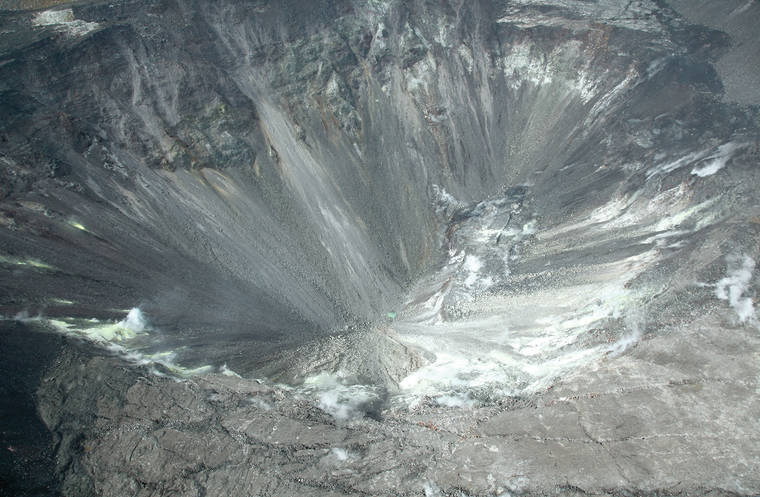
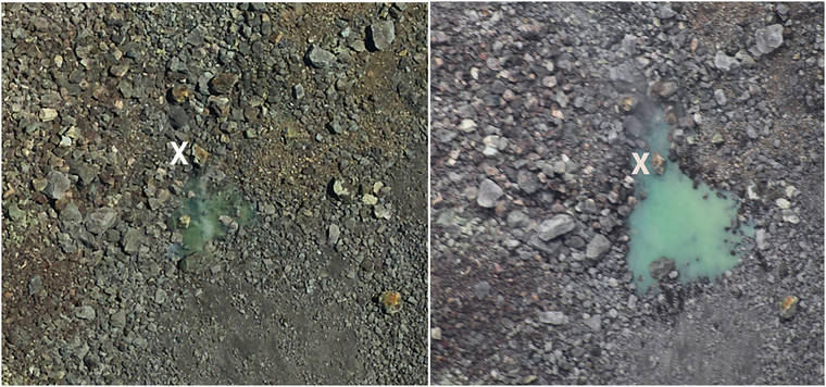
Telephoto views of water in the bottom of Halema‘uma‘u taken during a helicopter lidar survey July 25 (left), when the pond was first observed, and a USGS overflight on Aug. 1 (right). The pond grew slightly in size and depth between the two dates; an “X” marks the same rock in both photos for comparison.
USGS Hawaiian Volcano Observatory scientists usually base their research on observations, either visual or instrumental. Interpretations come from these observations, so they must be as good as possible. Incorrect observations can lead, and have led, to erroneous interpretations.
USGS Hawaiian Volcano Observatory scientists usually base their research on observations, either visual or instrumental. Interpretations come from these observations, so they must be as good as possible. Incorrect observations can lead, and have led, to erroneous interpretations.
But what if an observation is tempting but unverified? In that case, it’s time to hold the interpretations until the observation can be shown to be correct or incorrect.
ADVERTISING
On July 25, I was enjoying my birthday when a friend sent an email asking if HVO knew about water on the floor of Halema‘uma‘u.
Talk about a surprise!
The friend’s friend, a helicopter pilot, later sent a photo that showed a possible green pond on the crater floor and provided an oral account of it as being “about as large as a pickup truck.”
The next day, observers in the helicopter, which was collecting lidar data of Kilauea Volcano’s caldera, provided another photo. They said the smooth green patch looked like water, but they saw no reflection from its surface.
On July 30, a passenger in a different helicopter took a photo from a high altitude that showed a similar feature. This photo was posted on social media with a brief commentary.
So, is water at the bottom of Halema‘uma‘u — or not?
Everyone agreed that the photos could well show water, but could the green patch be something else?
Another possibility is that the smooth, green color comes from a flat surface underlain by ash or rock-fall dust blown from the wall of Halema‘uma‘u and trapped in the bottom of the crater. The green color could result from sulfur minerals or algae. A weak point of this idea is that large rocks adjacent to the supposed pond are not coated with ash, much less green ash.
HVO received several inquiries about the photographs and the possibility that they show water in the crater. Water was on everyone’s mind, and rightly so.
But Halema‘uma‘u has never had a pond of water since written observations began, so the presence of a pond would be unusual.
If there is water, the next question is where is it coming from? The floor of Halema‘uma‘u is now about 68 m (223 ft) below the level of the water table as measured in a deep well about 1 km (0.6 mi) farther south.
While tempting, speculation was not in order. No one saw a reflection or ripples on the purported pond of water, and all discussion was based on the suggestive, but non-definitive, photos. So, before HVO could begin assessing how water got there, we had to first be confident that water IS there.
With the “water or no water” question in mind, HVO scientists flew over the summit of Kilauea the morning of Aug. 1.
We can now confirm the presence of water at the bottom of Halema‘uma‘u. HVO observers on the helicopter overflight saw reflections from the green pond — the ‘smoking gun’ for water. The pond has clearly enlarged since the earliest photos from July 25.
With the presence of water confirmed, HVO scientists can now start thinking about the implications of water in the crater, relieved of the burden of having to prove its existence. Until we better understand where the water is coming from, it’s impossible to understand its significance.
However, at this time, there is no reason to think hazards at the summit have increased or decreased because of the presence of water.
HVO is now exploring options for additional observations.
The inaccessible location of the water — deep within Halema‘uma‘u — makes it impossible to see the pond from most parts of the crater rim, although one potential viewpoint will be examined in the coming days (weather permitting). If that proves out, a webcam can be installed with National Park Service permission to monitor the new pond. If not, remote sensing could be another option for continued observations.
HVO scientists will closely monitor the water in Halema‘uma‘u, and as more information about the pond becomes available we will keep readers informed through future Volcano Watch articles and posts to our website.
Stay tuned.
Volcano activity updates
Kilauea Volcano is not erupting and its USGS Volcano Alert level remains at Normal. For definitions of USGS Volcano Alert Levels, see https://volcanoes.usgs.gov/vhp/about_alerts.html.
Monitoring data for deformation have shown no significant changes in Kilauea activity during the past week. Rates of seismicity across the volcano remain low. Sulfur dioxide emission rates are low at the summit and below detection limits at Pu‘u ‘O‘o and the lower East Rift Zone.
Reflecting the current Normal alert level for Kilauea, HVO will transition in August from weekly to monthly updates for Kilauea.
Hazards remain at the lower ERZ and summit of Kilauea. Residents and visitors near the 2018 fissures, lava flows and summit collapse area should heed Hawaii County Civil Defense and Hawaii Volcanoes National Park closures and warnings. The 2018 lava flows are primarily on private property, and people are asked to be respectful and not enter or park on private property.
Mauna Loa is not erupting. Its USGS Volcano Alert level remains at Advisory because earthquake and ground deformation rates at the volcano continue to remain slightly elevated above long-term background levels. This alert level does not mean an eruption is imminent or that progression to an eruption is certain. A similar increase in activity occurred between 2014 and 2018 and no eruption occurred.
This past week, approximately 135 small-magnitude earthquakes (most less than M2.0) occurred beneath the summit and upper Southwest Rift Zone. Deformation measurements show continued summit inflation, suggestive of recharge of the volcano’s shallow magma storage system. No significant changes in volcanic gas release on the Southwest Rift Zone were measured, and fumarole temperatures there and at the summit remain unchanged.
For more information about the status of Mauna Loa, visit https://volcanoes.usgs.gov/volcanoes/mauna_loa/status.html
Three earthquakes with three or more felt reports occurred in Hawaii this past week: a magnitude-1.4 quake 2 km (1 mi) south of Pahala at -0 km (-0 mi) depth at 6:51 p.m. July 27; a magnitude-3.3 quake 26 km (16 mi) northwest of Pahala at -1 km (-1 mi) depth at 6:04 p.m. July 26; and a magnitude-3.0 quake 6 km (4 mi) southwest of Volcano at 0 km (0 mi) depth at 8:43 p.m. July 25.
HVO continues to closely monitor Kilauea and Mauna Loa for any signs of increased activity.
Visit HVO’s website (https://volcanoes.usgs.gov/hvo) for past Volcano Watch articles, Kilauea and Mauna Loa updates, volcano photos, maps, recent earthquake info, and more. Email questions to askHVO@usgs.gov.
Volcano Watch (https://volcanoes.usgs.gov/observatories/hvo/hvo_volcano_watch.html) is a weekly article and activity update written by U.S. Geological Survey Hawaiian Volcano Observatory scientists and affiliates.


