As officials work on a recovery plan, residents lament lack of access to homes, property


Hawaii County officials are targeting the end of the year for developing a proposed recovery plan for lower Puna.
Hawaii County officials are targeting the end of the year for developing a proposed recovery plan for lower Puna.
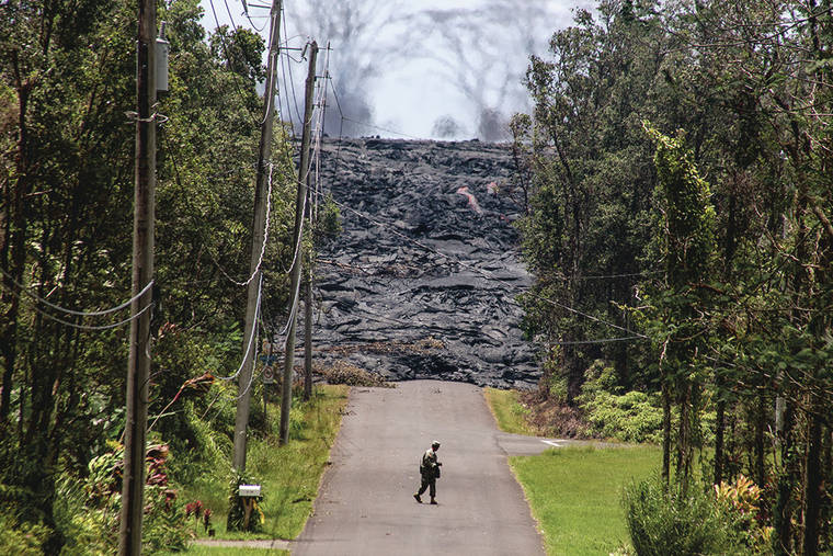
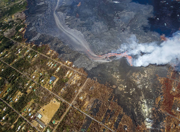
The area was devastated by a Kilauea eruption that lasted three to four months, destroyed 716 permitted structures and buried farms. A year later from the start of the disaster, large areas still lack permanent access as lava covered 9 miles of major roadways.
ADVERTISING
The plan will be the first post-disaster redevelopment since the 1960 tsunami, which resulted in some low-lying areas around Hilo Bay being repurposed to open space to reduce the risk from future tidal waves.
In some ways, this effort will repeat that process, though it’s being led by the county rather than the state.
“They went through a similar process,” said Ron Whitmore, county Research and Development deputy director.
“They changed land use policy,” he added. “They made decisions about decisions about what type of infrastructure to build and where.”
The same tasks are before the county following the eruption.
On April 11, the county signed a $1.6 million contract with consultant Tetra Tech to develop a long-term recovery plan, a process that will include public meetings and other methods of input, Whitmore said.
That will be combined with an economic recovery plan, that also look at the island’s economy as whole, in addition to Puna, and a risk assessment, which all together will determine how the affected area should be rebuilt and to what extent.
Whitmore said he hopes by the end of May to have a timeline for the community input process.
He said this won’t be something devised by planners behind closed doors. Land use and policy changes would be approved by the County Council.
“The purpose of the plan is to help policy makers, ultimately County Council members, really clearly understand in an objective way as possible the possible tradeoffs,” Whitmore said.
There are big decisions to consider.
As an example, the eruption wiped out entire subdivisions in Kapoho, where many of the lost structures were located. Property owners there still don’t have access because a large segment of Highway 137 remains covered.
Whether the highway there is restored, or if the route should be changed, is one question to tackle with major repercussions. Hundreds of homes were located there, including many vacation rentals and some farms.
The subdivisions bordered iconic tide pools and a bay that no longer exist.
County officials say no decision has been made, though Mayor Harry Kim, who lost a home in Kapoho, has said it is “very questionable” whether public dollars would be invested in that road again.
At least some Kapoho Vacationland property owners want to rebuild their subdivision, and have sought grants and loans from federal agencies to restore the private roads. But they also need road access from the county to get the money.
“I think people would like to hear the county is going to do something on (Highway) 137,” said Jan Marshall, who lost a home in Kapoho Vacationland. “Then we know what we can do.”
In January, the County Council passed a bill to add about $33 million in lava-related projects to the capital budget, which officials say included Highway 137 restoration. But they also say that’s just a placeholder and no funding has been approved yet.
If it’s ultimately decided not to rebuild certain infrastructure, the county could use the federal funds for alternative projects, said Diane Ley, Research and Development director. Those would likely be in the same area of the island, though they can be outside of it if they still serve people who were displaced, she said.
Smiley Burrows, a Leilani Estates resident who owns the property where Kapoho Crater, also known as Green Mountain sits, said residents have experienced a lot of false hope about the pace of road restoration.
She said they’ve received little clarity from county officials about how recovery funds from the state and federal governments will be spent. The worry is they could be spent outside of lower Puna.
So far, the county has received $22 million in state grants, and will receive another $60 million in loans and grants from the state after Gov. David Ige signed a disaster recovery bill. More funds are being sought from the federal government, in addition to what they will cover to replace lost infrastructure.
“I really feel at this point, the amount of money they are getting there in one way shape or form will benefit the island as a whole,” said Burrows, who is part of a coalition of community groups called I Mua Lower Puna. “But I don’t really see it particularly benefiting actual disaster victims.”
When asked about the timeline for repairs to Highway 137, the county Public Works Department replied that would be determined by the recovery plan. In total, about 4 miles of the highway is covered by lava rock.
The county built a temporary road over an inundated section on the Opihikao side of the route to restore access to Isaac Hale Beach Park and nearby properties in December.
In testimony to the council, Susan Kim, who lost a home in Kapoho Vacationland and is part of the I Mua Lower Puna coalition, urged the county to begin spending money on further road recovery as soon as possible.
The residents have repeated a simple message — recovery begins with roads.
“If you want to accelerate home construction, build the roads,” she said.
“If you want to get people back to work, build the roads.
“If you want more rental properties, build the roads.
“We’re asking for roads, not studies, not a framework. The roads that were already there and can be restored.”
Why not just rebuild the infrastructure as it was and not bother with the plans?
Whitmore said these are not simple decisions.
While it’s not the only area susceptible to lava flows, lower Puna consists of some of the most active areas on Kilauea, one of the world’s most active volcanoes. Last year’s eruption was the third in that part of East Rift Zone since 1955, not including the lava flow that threatened Pahoa in 2014.
An eruption in 1960 destroyed the village of Kapoho.
Geologists say it’s not a matter of if but when another eruption will occur there.
“They have huge long-term implications,” Whitmore said, regarding the decisions, “partly related to hazard mitigation. And they all have significant fiscal impacts.”
Meanwhile, the county says it plans to build a temporary road over lava-inundated areas of Highway 132, the costs of which the Federal Highway Administration says it will cover, by October.
However, whether the road is permanently restored there — with FHA picking up 80 percent of the cost — somewhere else or not at all, depends on an alternative study the county plans to have done in the summer.
About 3 miles of the road is covered.
“Depending on the results of the alternative study, Public Works may be faced with three options regarding Highway 132,” the department said in an emailed response.
“The study could determine that the road should not be rebuilt and the county assumes all liability and costs of upgrading the temporary road to a permanent road.
“A second possibility is that the county assumes liability and responsibility of maintaining a substandard road. A third possibility is that the road will be closed and/or only open for limited use.”
Other county roads at least partially covered by lava include Pohoiki Road, Hinalo Street, Honuaula Street, Lauone Street, Leilani Avenue and Lighthouse Road.
Preliminary estimates say cost of restoration of all roads that are eligible for FEMA reimbursement would be about $170 million, though the county is trying to refine that figure. FEMA covers 75 percent of the costs.
Email Tom Callis at tcallis@hawaiitribune-herald.com.


