With the current activity at Kilauea Volcano’s lower East Rift Zone and summit, it’s an understatement to say the volcano has been making worldwide headlines the past month.
To the uninitiated, the scientific and colloquial terms that are used to describe eruptive processes and products at Hawaii Volcanoes National Park might seem unusual or scary, when, in fact, they describe what’s been happening at Kilauea for more than three decades. So, today we address Kilauea’s current activity — what’s new and what’s not — starting with the two eruption sites: East Rift Zone and summit.
Kilauea Volcano’s East Rift Zone has been erupting nearly nonstop since 1983, with an eruption on the volcano’s middle East Rift Zone — generally referred to as the Pu‘u ‘O‘o eruption. (Pu‘u ‘O‘o is the volcanic cone built from the accumulation of cinder and spatter falling from episodic high lava fountains during the eruption’s first three years.)
For 35-plus years, lava erupting from vents on or near Pu‘u ‘O‘o created surface flows that advanced down the south flank of Kilauea. This changed on April 30 when magma from the middle East Rift Zone intruded into the lower part of the rift zone. This intrusion of magma ultimately resulted in the fissure vents now erupting in Hawaii Island’s lower Puna District. So, while an East Rift Zone eruption is not new, the location of the current vents (or fissures) is different from past vents.
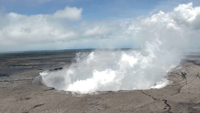
Kilauea’s summit eruption began in March 2008, when a vent opened in Halema‘uma‘u, a crater within the volcano’s summit caldera. For over 10 years, this vent was the site of a lava lake that rose and fell — sometimes fluctuating as much as 30 m (100 ft) in a 24-hour period — in concert with summit inflation and deflation. Throughout that time, rocks falling from the steep vent walls triggered numerous small gas-driven explosions that often blasted molten lava and pieces of older rock onto the rim of Halema‘uma‘u and adjacent caldera floor.
In early May 2018, in response to East Rift Zone changes, the summit lava lake dropped hundreds of meters (yards) and completely out of view. Concern grew that magma feeding the lava lake could drop below the water table, allowing groundwater to enter the system, which could cause steam-driven explosions. So, while small summit explosions are not new, the mechanism, vigor, plume heights and extent of ash fallout from the current explosive activity are.
We’ll now address what’s new — or not — with volcanic products and processes on Kilauea.
Sulfur dioxide: When a new eruptive vent opens on Kilauea, sulfur dioxide emissions increase — sometimes dramatically — as happened with the opening of the summit vent in 2008, the Kamoamoa fissure eruption in 2011, and now, with the lower East Rift Zone fissure eruption.
Sulfur dioxide is one of the three most abundant gases released during any volcanic eruption (the other two being water vapor and carbon dioxide), and it has been emitted in large quantities since the start of the Pu‘u ‘O‘o eruption in 1983. More info: https://vog.ivhhn.org/leilani-eruption.
Vog: Sulfur dioxide reacts with oxygen, sunlight, moisture and other gases and particles in the atmosphere to create a visible haze known as vog (volcanic air pollution), which has been an ongoing issue in Hawaii since 1983, as well as during all previous eruptions of Kilauea (and Mauna Loa). Increased sulfur dioxide emissions can result in more widespread and intense vog. Impacts depend on wind direction and your location — whether or not you’re downwind of the vog source — as well as your individual sensitivity. More info: https://pubs.usgs.gov/fs/2017/3017/fs20173017.pdf and https://vog.ivhhn.org/.
Laze: Since 1983, lava flows erupted from Kilauea have reached the ocean about half the time. The interaction of hot lava and cool seawater forms a white plume known as “laze” (lava haze), which is composed of condensed seawater steam, hydrochloric acid gas and tiny shards of volcanic glass. This corrosive mixture can irritate lungs, eyes and skin, but its effects diminish rapidly with distance from the ocean entry.
Ash: Small amounts of ash, which is carried by wind, have erupted from Kilauea’s summit vent since it opened in 2008. Where ash falls depends on the wind direction.
With recent changes at the summit, vigorous explosions have occurred more frequently at Halema‘uma‘u, resulting in higher, ash-laden plumes that can be blown far downwind.
More info: https://volcanoes.usgs.gov/observatories/hvo/faq_ash.html and https://vog.ivhhn.org/summit-ash-hazards.
Pele’s hair: Thin strands of volcanic glass, called “Pele’s hair” after the goddess of Hawaiian volcanoes, form when lava is thrown into the air or stretched into filaments (like pulling taffy).
Throughout Kilauea’s history, erupting lava fountains and lava lakes have produced Pele’s hair, which can be blown far downwind.
With Kilauea, as with so much else, the more things change, the more they stay the same.
Volcano
activity updates
On Kilauea Volcano’s East Rift Zone, lava continues to erupt from multiple points along the active fissure system in the Leilani Estates and Lanipuna Gardens area. As of June 1, fissure 8 lava flows were advancing toward the intersection of Highways 132 and 137 (Four Corners). Residents in the lower Puna District of Hawaii Island should remain informed and heed Hawaii County Civil Defense closures, warnings, and messages (http://www.hawaiicounty.gov/active-alerts). At Kilauea’s summit, ash emissions were diminished as of May 30, possibly reflecting the accumulation of rubble at the base of the growing summit eruptive vent, which was emitting a whitish plume of mostly steam. Earthquake activity remains high due to continued summit deflation. Additional explosive events that could produce minor amounts of ash fall downwind are possible at any time.
Volcanic gas emissions at the summit remain high.
Mauna Loa is not erupting. Rates of deformation and seismicity have not changed significantly over the past week.
The number of monthly and weekly earthquakes recorded beneath the volcano has decreased to near background levels.
Nineteen earthquakes were reported as felt in Hawaii during the past week. Due to ongoing deflation at Kilauea’s summit, there were 67 magnitude-3.0 and greater earthquakes in the summit region over the past week — the highest weekly number of summit region earthquakes ever recorded by HVO.
Visit HVO’s website (https://volcanoes.usgs.gov/hvo) for past Volcano Watch articles, Kilauea daily eruption updates, Mauna Loa weekly updates, volcano photos, maps, recent earthquake info, and more. Call for summary updates at 808-967-8862 (Kilauea) or 808-967-8866 (Mauna Loa). Email questions to askHVO@usgs.gov.
Volcano Watch (https://volcanoes.usgs.gov/hvo/hvo_volcano_watch.html) is a weekly article and activity update written by U.S. Geological Survey Hawaiian Volcano Observatory scientists and affiliates.