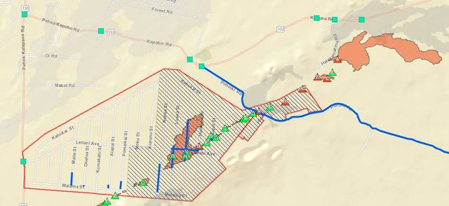
A 22nd fissure has reportedly opened near Leilani Estates.
A 22nd fissure has reportedly opened near Leilani Estates.
The Hawaiian Volcano Observatory reported Friday morning that fissure 22 opened between fissures 19 and 20 and is currently active.
Other flows are actively spattering lava. Fissure 17, which generated a significant eastward lava flow earlier this week, continues to cover its previous flow with new lava, but no new advancement has occurred.
Mask distribution centers will be open today from 1 – 7 p.m. at Cooper Center in Volcano and Ocean View Community Center. While the masks will filter out airborne particulates such as ash, they offer no protection against toxic volcanic fumes.
A third shelter has opened at the Sure Foundation Church on Pohaku Circle in Keaau. The shelter is intended to house evacuees with breathing difficulties, but all are welcome.